ZCZC MIATWOAT ALL
TTAA00 KNHC DDHHMM
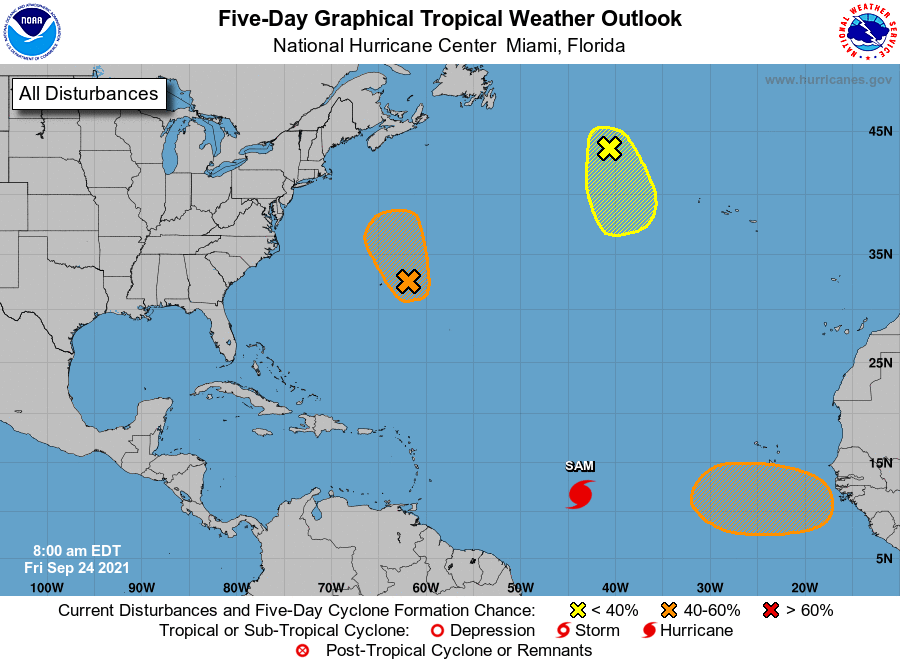
Tropical Weather Outlook
NWS National Hurricane Center Miami FL
800 AM EDT Fri Sep 24 2021
For the North Atlantic...Caribbean Sea and the Gulf of Mexico:
The National Hurricane Center is issuing advisories on recently
upgraded Hurricane Sam, located about 1400 miles east-southeast of
the northern Leeward Islands.
1. A large area of showers and thunderstorms centered a couple
hundred miles east of Bermuda is associated with a formative surface
low interacting with an upper-level trough. Additional tropical or
subtropical development of this system could occur through early
Saturday as it moves generally north-northwestward. After that
time, development is not expected due to strong upper-level winds.
Additional information on this system, including gale warnings, can
be found in High Seas Forecasts issued by the National Weather
Service.
* Formation chance through 48 hours...medium...40 percent.
* Formation chance through 5 days...medium...40 percent.
2. A gale-force, non-tropical low pressure system, the remnants of
Odette, is located a little less than 600 miles west-northwest of
the westernmost Azores. Showers and thunderstorms remain limited
near the low, and the window of opportunity for this system to
become a subtropical or tropical cyclone is closing as strong
upper-level winds are expected to develop over the system later
today. This system will move generally south-southeastward over the
next day or two. Additional information on this system, including
gale warnings, can be found in High Seas Forecasts issued by the
National Weather Service.
* Formation chance through 48 hours...low...20 percent.
* Formation chance through 5 days...low...20 percent.
3. A tropical wave is expected to move off the west coast of Africa by
the end of this weekend. Thereafter, environmental conditions are
forecast to be conducive for gradual development, and a tropical
depression could form by the middle of next week while the system
moves westward at 10 to 15 mph over the far eastern tropical
Atlantic.
* Formation chance through 48 hours...low...near 0 percent.
* Formation chance through 5 days...medium...40 percent.
High Seas Forecasts issued by the National Weather Service can be
found under AWIPS header NFDHSFAT1, WMO header FZNT01 KWBC, and
online at ocean.weather.gov/shtml/NFDHSFAT1.php
Forecaster Papin