ZCZC MIATWOAT ALL
TTAA00 KNHC DDHHMM
Tropical Weather Outlook
NWS National Hurricane Center Miami FL
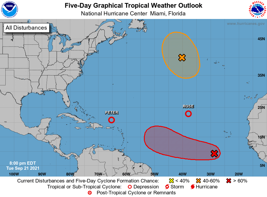
800 PM EDT Tue Sep 21 2021
For the North Atlantic...Caribbean Sea and the Gulf of Mexico:
The National Hurricane Center is issuing advisories on Tropical
Depression Peter, located a couple of hundred miles northeast
of Puerto Rico, and on Tropical Storm Rose, located about 1000
miles west-northwest of the Cabo Verde Islands.
1. Showers and thunderstorms associated with a tropical wave located
several hundred miles southwest of the Cabo Verde Islands have
increased since this morning and are beginning to show signs of
organization. Recent satellite wind data also indicate that a broad
area of low pressure has formed, but the system lacks a well-defined
center. Environmental conditions are expected to remain conducive
for additional development, and a tropical depression is likely to
form within the next day or two while the system moves westward at
10 to 15 mph across the eastern and central tropical Atlantic Ocean.
* Formation chance through 48 hours...high...80 percent.
* Formation chance through 5 days...high...90 percent.
2. A gale-force, non-tropical low pressure system, the remnants of
Odette, is located about 500 miles west of the westernmost Azores.
This low could acquire some subtropical characteristics over
marginally warm waters during the next few days while it executes a
small counter-clockwise loop over the north-central Atlantic Ocean.
However, by the end of the week, this system is expected to
encounter more hostile environmental conditions. Additional
information on this system, including gale warnings, can be found in
High Seas Forecasts issued by the National Weather Service.
* Formation chance through 48 hours...low...30 percent.
* Formation chance through 5 days...medium...50 percent.
High Seas Forecasts issued by the National Weather Service can be
found under AWIPS header NFDHSFAT1, WMO header FZNT01 KWBC, and
online at ocean.weather.gov/shtml/NFDHSFAT1.php
Forecaster Brown