ZCZC MIATWOAT ALL
TTAA00 KNHC DDHHMM
Tropical Weather Outlook
NWS National Hurricane Center Miami FL
800 PM EDT Mon Sep 20 2021
For the North Atlantic...Caribbean Sea and the Gulf of Mexico:
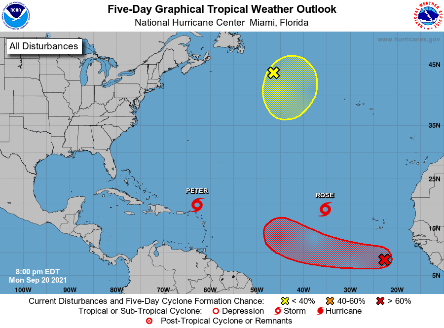
The National Hurricane Center is issuing advisories on Tropical
Storm Peter, located about 150 miles northeast of the northern
Leeward Islands, and on Tropical Storm Rose, located over the
eastern tropical Atlantic Ocean.
1. Showers and thunderstorms associated with a tropical wave located
several hundred miles south of the Cabo Verde Islands continue to
show some signs of organization, although recent satellite wind data
indicate that the system lacks a surface circulation. Upper-level
winds, however, are expected to become conducive for further
development during the next day or two, and a tropical depression is
likely to form by Thursday or Friday while the system moves westward
at 10 to 15 mph across the eastern and central tropical Atlantic
Ocean.
* Formation chance through 48 hours...medium...40 percent.
* Formation chance through 5 days...high...80 percent.
2. A storm-force, non-tropical low pressure system, the remnants of
Odette, is located several hundred miles southeast of Newfoundland.
This low could acquire some subtropical characteristics by the
middle of this week as it moves slowly southeastward over warmer
waters across the north-central Atlantic Ocean, before it moves
northward over cooler waters over the weekend. Additional
information on this system, including storm warnings, can be found
in High Seas Forecasts issued by the National Weather Service.
* Formation chance through 48 hours...low...10 percent.
* Formation chance through 5 days...low...30 percent.
High Seas Forecasts issued by the National Weather Service can be
found under AWIPS header NFDHSFAT1, WMO header FZNT01 KWBC, and
online at ocean.weather.gov/shtml/NFDHSFAT1.php
Forecaster Brown