ZCZC MIATWOAT ALL
TTAA00 KNHC DDHHMM
Tropical Weather Outlook
NWS National Hurricane Center Miami FL
200 AM EDT Fri Sep 17 2021
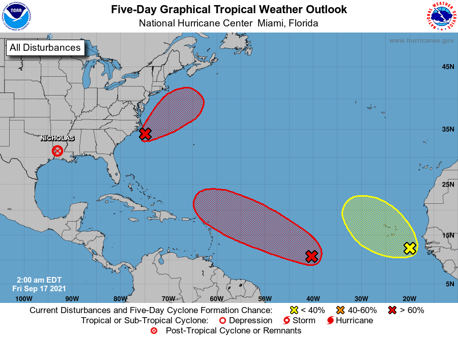
For the North Atlantic...Caribbean Sea and the Gulf of Mexico:
The Weather Prediction Center is issuing advisories on
Post-Tropical Cyclone Nicholas, located over Louisiana.
1. Showers and thunderstorms remain disorganized in association with a
tropical wave and broad area of low pressure located about 1100
miles west-southwest of the Cabo Verde Islands. However,
environmental conditions are expected to be conducive for
development during the next few days, and a tropical depression
could still form over the weekend. This system is expected to move
westward to west-northwestward at 15 to 20 mph across the tropical
Atlantic during the next several days.
* Formation chance through 48 hours...medium...60 percent.
* Formation chance through 5 days...high...70 percent.
2. A broad area of low pressure is located about 100 miles southeast
of the Outer Banks of North Carolina. Although the circulation of
this system has become a little better defined since yesterday, the
associated showers and thunderstorms remain disorganized and
located mainly well to the east of the center. Environmental
conditions are becoming more conducive for development, and a
tropical depression is likely to form during the next day or so
while the system moves northward to north-northeastward off the
southeast and mid-Atlantic U.S. coasts. Regardless of development,
this system could bring high surf to portions of the southeast and
mid-Atlantic U.S. coasts through this weekend. Additional
information on this system, including gale warnings, can be found in
High Seas Forecasts issued by the NOAA Ocean Prediction Center.
* Formation chance through 48 hours...high...70 percent.
* Formation chance through 5 days...high...70 percent.
3. Disorganized cloudiness and thunderstorms over the far eastern
tropical Atlantic are associated with a tropical wave located a few
hundred miles southeast of the Cabo Verde Islands. Environmental
conditions are forecast to be only marginally conducive, and
development, if any, of this system should be slow to occur over the
next few days while the system moves west-northwestward to
northwestward over the far eastern Atlantic.
* Formation chance through 48 hours...low...10 percent.
* Formation chance through 5 days...low...20 percent.
Public advisories issued by the Weather Prediction Center on
Post-Tropical Cyclone Nicholas can be found under AWIPS header
TCPAT4, WMO header WTNT34 KWNH, and on the web at
https://www.wpc.ncep.noaa.gov or hurricanes.gov
High Seas Forecasts for the system off the Outer Banks of North
Carolina issued by the NOAA Ocean Prediction Center can be found
under AWIPS header NFDHSFAT1, WMO header FZNT01 KWBC, and online at
ocean.weather.gov/shtml/NFDHSFAT1.php
Forecaster Pasch