ZCZC MIATWOAT ALL
TTAA00 KNHC DDHHMM
Tropical Weather Outlook
NWS National Hurricane Center Miami FL
800 PM EDT Wed Sep 15 2021
For the North Atlantic...Caribbean Sea and the Gulf of Mexico:
The Weather Prediction Center is issuing advisories on Tropical
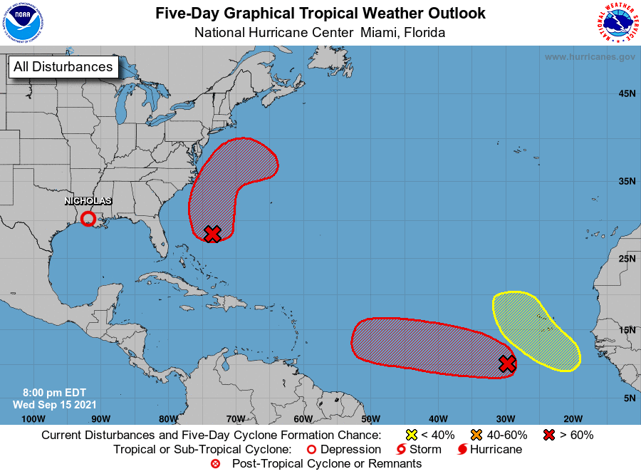
Depression Nicholas, located over southwestern Louisiana.
1. Showers and thunderstorms have changed little in organization in
association with an area of low pressure located several hundred
miles southwest of the Cabo Verde Islands. Environmental
conditions are expected to remain conducive for development, and a
tropical depression is likely to form within the next couple of
days. This system is expected to move westward to
west-northwestward across the tropical Atlantic during the next
several days.
* Formation chance through 48 hours...high...80 percent.
* Formation chance through 5 days...high...90 percent.
2. A low pressure system located about midway between the Bahamas and
Bermuda is producing poorly organized shower activity. An Air
Force Reserve Hurricane Hunter aircraft investigating the system
this afternoon reported that the circulation was disorganized and
that the strongest winds were well to the east of the center.
Environmental conditions are expected to become more conducive for
development, and a tropical depression is likely to form during the
next day or two while the system moves north-northwestward to
northward off the southeast U.S. coast. Regardless of development,
this system could bring high surf to portions of the southeast and
mid-Atlantic U.S. coasts later this week.
* Formation chance through 48 hours...high...70 percent.
* Formation chance through 5 days...high...70 percent.
3. A tropical wave is expected to emerge off the west coast of
Africa in a day or two. Thereafter, environmental conditions are
forecast to be conducive for development while the system moves
generally west-northwestward to northwestward over the
far eastern Atlantic.
* Formation chance through 48 hours...low...near 0 percent.
* Formation chance through 5 days...low...20 percent.
Public advisories issued by the Weather Prediction Center on
Tropical Depression Nicholas can be found under AWIPS header TCPAT4,
WMO header WTNT34 KWNH, and on the web at
https://www.wpc.ncep.noaa.gov or hurricanes.gov
Forecaster Beven