ZCZC MIATWOAT ALL
TTAA00 KNHC DDHHMM
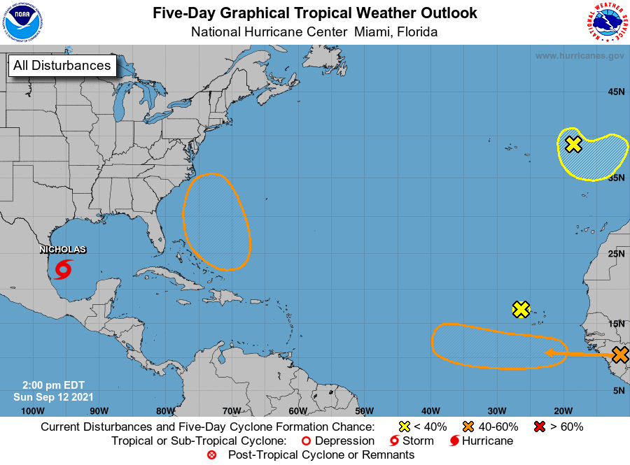
Tropical Weather Outlook
NWS National Hurricane Center Miami FL
200 PM EDT Sun Sep 12 2021
For the North Atlantic...Caribbean Sea and the Gulf of Mexico:
The National Hurricane Center is issuing advisories on newly formed
Tropical Storm Nicholas, located over the southwestern Gulf of
Mexico.
1. Shower activity associated with a tropical wave located just
west of the westernmost Cabo Verde Islands has diminished since
this morning. Environmental conditions have become unfavorable,
and significant development of this system is no longer expected.
* Formation chance through 48 hours...low...near 0 percent.
* Formation chance through 5 days...low...near 0 percent.
2. Shower and thunderstorm activity remains limited in association
with a non-tropical area of low pressure located over the far
northeastern Atlantic a few hundred miles east-northeast of the
Azores. This system is forecast to move south-southeastward towards
warmer waters, which could allow the low to gradually acquire some
tropical or subtropical characteristics during the next day or so.
After that time, the system is forecast to move inland over
Portugal ending any further development chance.
* Formation chance through 48 hours...low...20 percent.
* Formation chance through 5 days...low...20 percent.
3. Another tropical wave is forecast to move off the west coast of
Africa on Monday. Gradual development of this system is possible
thereafter, and a tropical depression could form by the middle of
the week while it moves westward across the eastern tropical
Atlantic Ocean.
* Formation chance through 48 hours...low...20 percent.
* Formation chance through 5 days...medium...60 percent.
4. An area of low pressure is expected to form north of the
southeastern or central Bahamas in a few days resulting from a
tropical wave interacting with an upper-level trough. Gradual
development of this system is possible, and a tropical depression
could form later this week several hundred miles southeast of the
Carolinas while it moves northwestward across the western Atlantic.
* Formation chance through 48 hours...low...near 0 percent.
* Formation chance through 5 days...medium...50 percent.
Public Advisories on Tropical Storm Nicholas are issued under
WMO header WTNT34 KNHC and under AWIPS header MIATCPAT4.
Forecast/Advisories on Tropical Storm Nicholas are issued under
WMO header WTNT24 KNHC and under AWIPS header MIATCMAT4.
Forecaster Brown