ZCZC MIATWOAT ALL
TTAA00 KNHC DDHHMM
Tropical Weather Outlook
NWS National Hurricane Center Miami FL
200 AM EDT Sat Sep 11 2021
For the North Atlantic...Caribbean Sea and the Gulf of Mexico:
The National Hurricane Center is issuing advisories on Hurricane
Larry, located over Newfoundland, Canada.
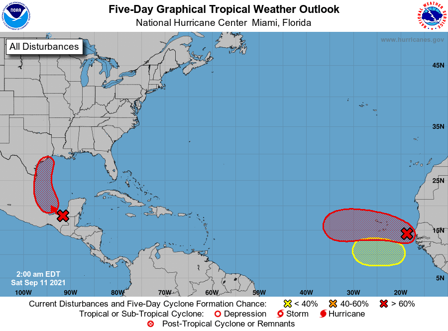
1. Disorganized showers and thunderstorms over portions of Central
America, southeastern Mexico, and the adjacent waters of the
northwestern Caribbean Sea and southern Gulf of Mexico are
associated with a tropical wave interacting with an upper-level
trough. Upper-level winds over the western Gulf of Mexico are
expected to become more conducive for development over the weekend,
and a tropical depression is likely to form on Sunday or Monday
while the system moves northwestward and then northward near the
coast of northeastern Mexico. Further development of this system
will be possible through the middle of next week if it remains over
water, and interests along the western and northwestern Gulf coast
should monitor the progress of this system.
Regardless of development, this disturbance is expected to produce
heavy rain across portions of Central America and the Yucatan
Peninsula today, which may lead to flash flooding and mudslides.
By late this weekend, heavy rain will likely reach portions of the
western Gulf coast, including coastal Texas and Louisiana through
the middle of next week. Localized significant rainfall amounts
will be possible, resulting in limited flash and urban flooding.
* Formation chance through 48 hours...high...70 percent.
* Formation chance through 5 days...high...80 percent.
2. A tropical wave is producing a concentrated area of showers and
thunderstorms between Senegal and the Cabo Verde Islands.
Environmental conditions appear generally conducive for additional
development, and a tropical depression is likely to form late this
weekend or early next week while the system moves generally
westward over the far eastern Atlantic near the Cabo Verde Islands.
Interests in the Cabo Verde Islands should monitor the progress of
this system.
* Formation chance through 48 hours...medium...50 percent.
* Formation chance through 5 days...high...70 percent.
3. Another tropical wave is expected to move off the west coast of
Africa early next week. Some development of this system will be
possible through the middle of next week while it moves westward
across the eastern tropical Atlantic Ocean.
* Formation chance through 48 hours...low...near 0 percent.
* Formation chance through 5 days...low...20 percent.
Forecaster Berg