ZCZC MIATWOAT ALL
TTAA00 KNHC DDHHMM
Tropical Weather Outlook
NWS National Hurricane Center Miami FL
200 PM EDT Fri Sep 10 2021
For the North Atlantic...Caribbean Sea and the Gulf of Mexico:
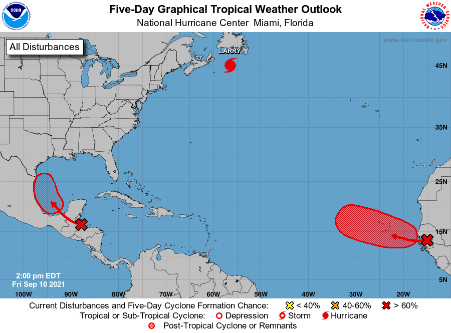
The National Hurricane Center is issuing advisories on Hurricane
Larry, located over the western Atlantic several hundred miles
southwest of Newfoundland, Canada.
1. The northern part of a tropical wave is producing disorganized
showers and thunderstorms over the western Caribbean Sea, and
portions of Central America and the Yucatan peninsula. This system
is forecast to move into the Bay of Campeche and merge with a
pre-existing surface trough by Sunday. Environmental conditions are
expected to be conducive to support gradual development thereafter,
and a tropical depression is likely to form on Sunday or Monday
before the system moves onshore along the western Gulf of Mexico
coast. Regardless of development, this disturbance is expected to
produce heavy rains across portions of Central America and the
Yucatan Peninsula through Saturday. Heavy rains are likely to
reach portions of the western Gulf coast late this weekend.
* Formation chance through 48 hours...medium...40 percent.
* Formation chance through 5 days...high...70 percent.
2. A strong tropical wave located along the west coast of Africa is
producing disorganized showers and thunderstorms. This wave will
move off the coast by this evening, and gradual development is
expected thereafter. A tropical depression is likely to form late
this weekend or early next week as the system moves
west-northwestward over the far eastern Atlantic near the Cabo Verde
Islands. Interests in the Cabo Verde Islands should monitor the
progress of this system.
* Formation chance through 48 hours...medium...50 percent.
* Formation chance through 5 days...high...70 percent.
Forecaster Cangialosi