ZCZC MIATWOAT ALL
TTAA00 KNHC DDHHMM
Tropical Weather Outlook
NWS National Hurricane Center Miami FL
200 PM EDT Sat Sep 4 2021
For the North Atlantic...Caribbean Sea and the Gulf of Mexico:
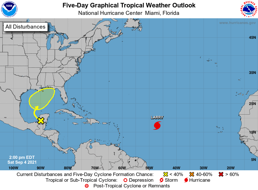
The National Hurricane Center is issuing advisories on Hurricane
Larry, located over the central tropical Atlantic about 1100 miles
east of the Leeward Islands.
1. A weak surface trough over portions of the western Yucatan Peninsula
of Mexico is producing disorganized shower and thunderstorm
activity. The disturbance is forecast to move northwestward over
the southwestern Gulf of Mexico on Sunday, then moved northward or
northeastward over the western or central Gulf of Mexico Monday and
Tuesday. Unfavorable upper-level winds are expected to limit
development through Monday, but environmental conditions could
become marginally favorable for some gradual development on Tuesday
or Wednesday. Regardless of development, locally heavy rains are
possible over portions of the Yucatan Peninsula and northern Central
America through Sunday.
* Formation chance through 48 hours...low...near 0 percent.
* Formation chance through 5 days...low...30 percent.
Forecaster Beven