ZCZC MIATWOAT ALL
TTAA00 KNHC DDHHMM
Tropical Weather Outlook
NWS National Hurricane Center Miami FL
200 AM EDT Mon Aug 30 2021
For the North Atlantic...Caribbean Sea and the Gulf of Mexico:
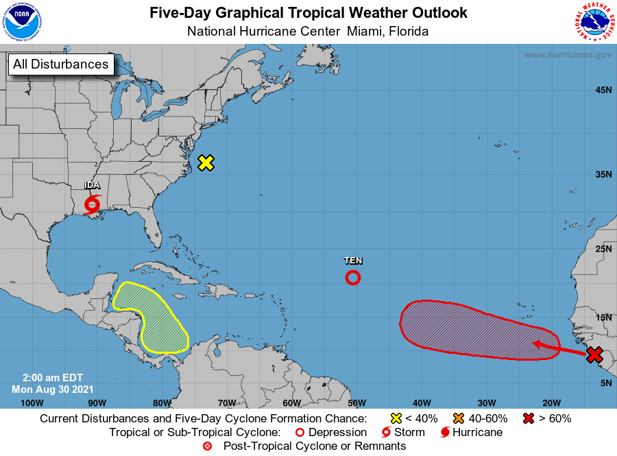
The National Hurricane Center is issuing advisories on Hurricane
Ida, located inland over southeastern Louisiana, on Tropical
Depression Ten, located over the central tropical Atlantic, and has
issued the last advisory on Post-Tropical Cyclone Julian, moving
rapidly northeastward over the central subtropical Atlantic.
1. Showers and thunderstorms have mostly diminished with the broad area
of low pressure located east of the Delmarva Peninsula. Upper-level
winds are expected to increase over the low tomorrow, and its
prospects for further development have decreased as it drifts slowly
away from the east coast of the United States.
* Formation chance through 48 hours...low...near 0 percent.
* Formation chance through 5 days...low...near 0 percent.
2. A tropical wave is expected to emerge off the west coast of Africa
later today. Environmental conditions appear conducive for the
development of a low pressure area once the wave moves offshore, and
a tropical depression is likely to form by the middle or latter part
of the week while the system moves west-northwestward at 10 to 15
mph over the eastern tropical Atlantic.
* Formation chance through 48 hours...medium...60 percent.
* Formation chance through 5 days...high...80 percent.
3. A broad area of low pressure is expected to form in the southern
Caribbean Sea over the next several days. Environmental conditions
appear to be favorable for some slow development by the end of the
week, as long as the system remains over water. This system is
expected to move gradually west-northwestward or northwestward at 5
to 10 mph over the western Caribbean Sea close to the east coast of
Central America.
* Formation chance through 48 hours...low...near 0 percent.
* Formation chance through 5 days...low...20 percent.
Forecaster Papin