ZCZC MIATWOAT ALL
TTAA00 KNHC DDHHMM
Tropical Weather Outlook
NWS National Hurricane Center Miami FL
800 PM EDT Fri Aug 27 2021
For the North Atlantic...Caribbean Sea and the Gulf of Mexico:
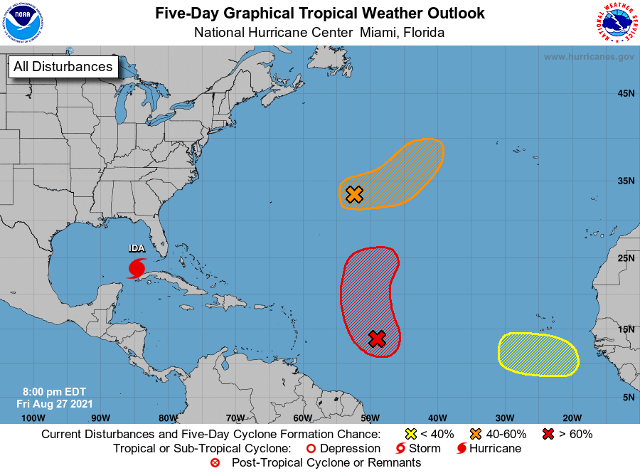
The National Hurricane Center is issuing advisories on Hurricane
Ida, located over western Cuba.
1. An elongated area of low pressure located over the central Atlantic
several hundred miles east of Bermuda is producing disorganized
showers and a couple of thunderstorms. Environmental conditions are
expected to be only marginally conducive for development, however,
a tropical depression could still form by early next week. By
midweek, the system is forecast to be absorbed by a frontal system.
The disturbance is expected to drift eastward through tonight and
Saturday, then accelerate northeastward Sunday toward the central
north Atlantic.
* Formation chance through 48 hours...medium...40 percent.
* Formation chance through 5 days...medium...60 percent.
2. Satellite images indicate that an area of low pressure has developed
in association with a tropical wave located several hundred miles
east of the Lesser Antilles. However, shower and thunderstorm
activity is limited near the center of the low. Some additional
development of this system is expected, and a tropical depression is
likely to form Saturday or Saturday night before it moves into an
environment of stronger upper-level winds and slightly cooler
waters. The disturbance is forecast to move west-northwestward
through tonight, then turn northward Saturday.
* Formation chance through 48 hours...high...80 percent.
* Formation chance through 5 days...high...80 percent.
3. Another tropical wave is expected to emerge off of the west African
coast by the middle of next week. Afterwards, environmental
conditions appear marginally conducive for gradual development
toward the end of next week as the system moves west-northwestward
to northwestward at 10 to 15 mph.
* Formation chance through 48 hours...low...near 0 percent.
* Formation chance through 5 days...low...30 percent.
Forecaster Latto