ZCZC MIATWOAT ALL
TTAA00 KNHC DDHHMM CCA
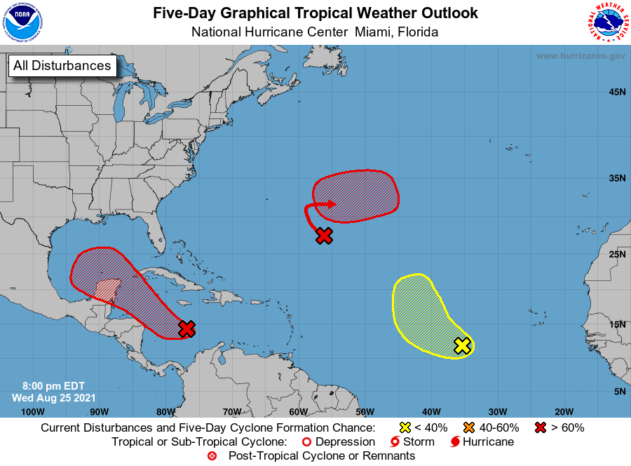
Tropical Weather Outlook...Corrected
NWS National Hurricane Center Miami FL
800 PM EDT Wed Aug 25 2021
Corrected 48-h formation chance in first paragraph
For the North Atlantic...Caribbean Sea and the Gulf of Mexico:
1. A broad area of low pressure is expected to form over the western
Caribbean Sea during the next day or so from a tropical wave
currently located north of Colombia. Environmental conditions are
forecast to be conducive for development, and a tropical depression
or tropical storm is likely to form late this week or over the
weekend. The system is expected to move northwestward over the
northwestern Caribbean Sea and near or across the Yucatan Peninsula
of Mexico on Friday and into the Gulf of Mexico this weekend, where
conditions are expected to be favorable for additional development.
Regardless of development, heavy rainfall and flooding will be
possible through the weekend in portions of Central America and the
Yucatan Peninsula. In addition, this system could bring dangerous
impacts from storm surge, wind, and heavy rainfall to portions of
the coasts of Louisiana, Texas, and the Mexican state of Tamaulipas
late this weekend and early next week. However, uncertainty remains
large since the system has yet to form. Interests in these areas
should closely monitor the progress of this system and ensure they
have their hurricane plan in place. An Air Force Reserve
reconnaissance aircraft is scheduled to investigate the system
Thursday afternoon, if necessary.
* Formation chance through 48 hours...medium...60 percent.
* Formation chance through 5 days...high...80 percent.
2. A broad trough of low pressure is producing disorganized showers and
thunderstorms over the central tropical Atlantic about 650 miles
east-southeast of Bermuda. Only slow development of this system is
expected during the next day or so due to unfavorable upper-level
winds. Afterwards, environmental conditions are forecast to become
more conducive for development, and a tropical depression is likely
to form late this week or this weekend while the system turns
eastward over the central Atlantic.
* Formation chance through 48 hours...medium...40 percent.
* Formation chance through 5 days...high...80 percent.
3. A tropical wave over the far eastern tropical Atlantic located
several hundred miles west-southwest of the Cabo Verde Islands is
producing disorganized showers and thunderstorms. Some development
of this system is possible over the next several days while it moves
west-northwestward at 10 to 15 mph over the eastern tropical
Atlantic. Upper-level winds are forecast to become less conducive
for development by early next week.
* Formation chance through 48 hours...low...20 percent.
* Formation chance through 5 days...low...30 percent.
Forecaster Pasch