ZCZC MIATWOAT ALL
TTAA00 KNHC DDHHMM
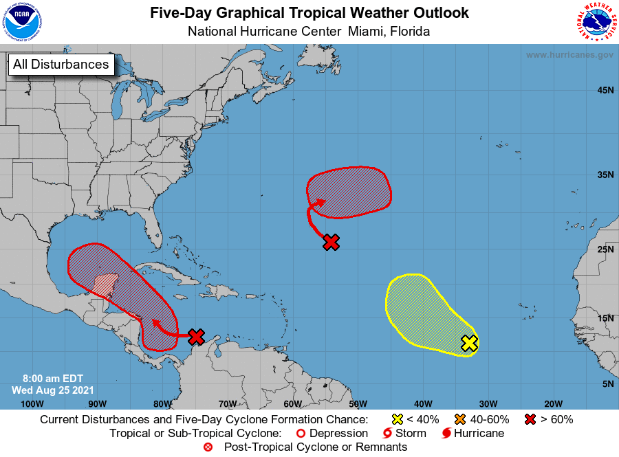
Tropical Weather Outlook
NWS National Hurricane Center Miami FL
800 AM EDT Wed Aug 25 2021
For the North Atlantic...Caribbean Sea and the Gulf of Mexico:
1. A broad area of low pressure is expected to form over the
southwestern Caribbean Sea during the next day or so from a tropical
wave currently located over northwestern Colombia and the
south-central Caribbean Sea. Environmental conditions are forecast
to be conducive for development, and a tropical depression is likely
to form late this week or over the weekend while the system moves
west-northwestward to northwestward over the northwestern Caribbean
Sea. The disturbance is expected to move near or across the Yucatan
Peninsula of Mexico on Saturday, and move into the western Gulf of
Mexico by Sunday where conditions could be favorable for additional
development to occur.
* Formation chance through 48 hours...medium...40 percent.
* Formation chance through 5 days...high...80 percent.
2. A broad trough of low pressure is producing disorganized showers and
thunderstorms over the central tropical Atlantic about 800 miles
southeast of Bermuda. Only slow development of this system is
expected during the next day or so due to unfavorable upper-level
winds. Afterwards, environmental conditions are forecast to become
more conducive for development, and a tropical depression is likely
to form late this week or this weekend while the system turns
eastward over the central Atlantic.
* Formation chance through 48 hours...low...30 percent.
* Formation chance through 5 days...high...80 percent.
3. A tropical wave over the far eastern tropical Atlantic located
several hundred miles southwest of the Cabo Verde Islands is
producing a disorganized area of showers and thunderstorms. Some
development of this system is possible over the next several days
while it moves west-northwestward at 10 to 15 mph over the eastern
tropical Atlantic. Upper-level winds are forecast to become less
conducive for development by this weekend.
* Formation chance through 48 hours...low...20 percent.
* Formation chance through 5 days...low...30 percent.
Forecaster Stewart