ZCZC MIATWOAT ALL
TTAA00 KNHC DDHHMM
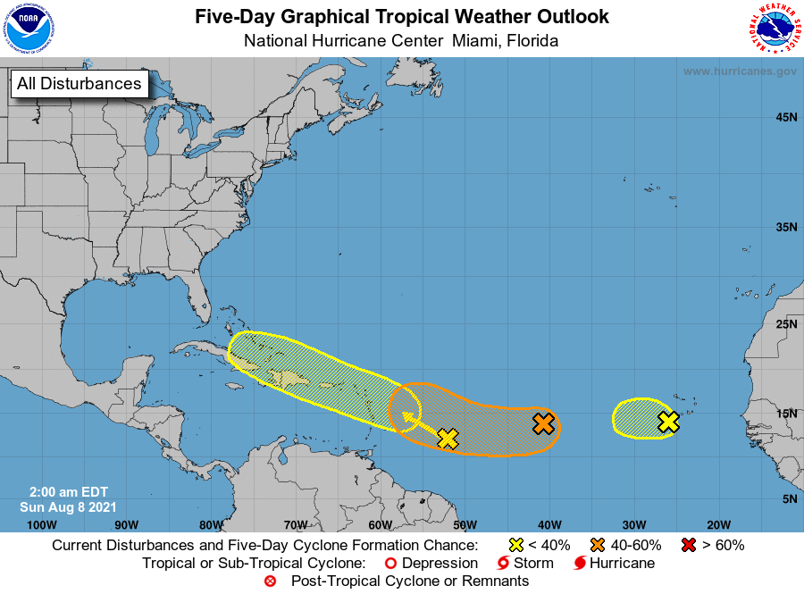
Tropical Weather Outlook
NWS National Hurricane Center Miami FL
200 AM EDT Sun Aug 8 2021
For the North Atlantic...Caribbean Sea and the Gulf of Mexico:
1. Showers and thunderstorms associated with a broad area of low
pressure located about a hundred miles southwest of the
southwesternmost Cabo Verde Islands have diminished. Strong
upper-level winds and cooler waters are expected to prevent
significant development of this system while it moves toward the
west or west-northwest at about 10 mph during the next few days.
Regardless of development, locally heavy rainfall and gusty winds
still are possible over portions of the westernmost Cabo Verde
Islands through Sunday.
* Formation chance through 48 hours...low...20 percent.
* Formation chance through 5 days...low...20 percent.
2. An area of low pressure located over the tropical Atlantic about a
thousand miles west of the Cabo Verde Islands continues to produce
shower and thunderstorm activity to the southwest of its center.
Environmental conditions are expected to become a little more
favorable for gradual development over the next several days, and
this system could become a tropical depression by the middle of this
week. The system is forecast to move slowly toward the
west-southwest or west during the next couple of days, and then move
a little faster toward the west-northwest by mid-week.
* Formation chance through 48 hours...low...20 percent.
* Formation chance through 5 days...medium...40 percent.
3. An area of low pressure is producing disorganized showers and
thunderstorms over the tropical Atlantic several hundred miles east
of the Windward Islands. Some gradual development of this system is
possible while it moves west-northwestward at 10 to 15 mph, reaching
portions of the Lesser Antilles late Monday and then moving across
the eastern Caribbean Sea and Greater Antilles through the middle of
this week.
* Formation chance through 48 hours...low...20 percent.
* Formation chance through 5 days...low...30 percent.
Forecaster Pasch