ZCZC MIATWOAT ALL
TTAA00 KNHC DDHHMM
Tropical Weather Outlook
NWS National Hurricane Center Miami FL
Issued by the NWS Weather Prediction Center College Park MD
200 PM EDT Tue Jun 15 2021
For the North Atlantic...Caribbean Sea and the Gulf of Mexico:
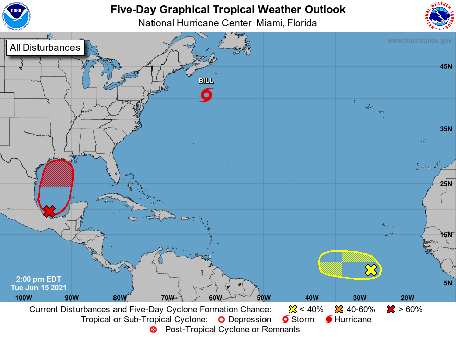
The National Hurricane Center is issuing advisories on Tropical
Storm Bill, located a few hundred miles south-southeast of Halifax,
Canada.
1. Disorganized showers and thunderstorms continue over the Bay
of Campeche and southern Mexico in association with a broad
low pressure area. This system is expected to move little during
the next day or two, and any development should be slow to occur
during that time period due to its close proximity to land.
However, the disturbance should begin to move northward by
Thursday, and a tropical depression is likely to form late in
the week when the low moves across the central and
northwestern Gulf of Mexico. Regardless of development,
heavy rainfall will continue over portions of Central America
and southern Mexico during the next several days. Heavy rains
could also begin to impact portions of the northern Gulf Coast
on Friday. Please consult products from your local
meteorological service for more information.
* Formation chance through 48 hours...medium...40 percent.
* Formation chance through 5 days...high...80 percent.
Shower activity is limited in association with a tropical
wave located a few hundred miles south-southwest of the Cabo Verde
Islands. Development, if any, should be slow to occur during the
next couple of days while the wave moves westward. Thereafter, a
combination of dry air aloft and strong upper-level winds should
end the chances of formation when the wave reaches the central
tropical Atlantic.
2. * Formation chance through 48 hours...low...10 percent.
* Formation chance through 5 days...low...10 percent.
Forecaster Cangialosi/Roth