ZCZC MIATWOAT ALL
TTAA00 KNHC DDHHMM
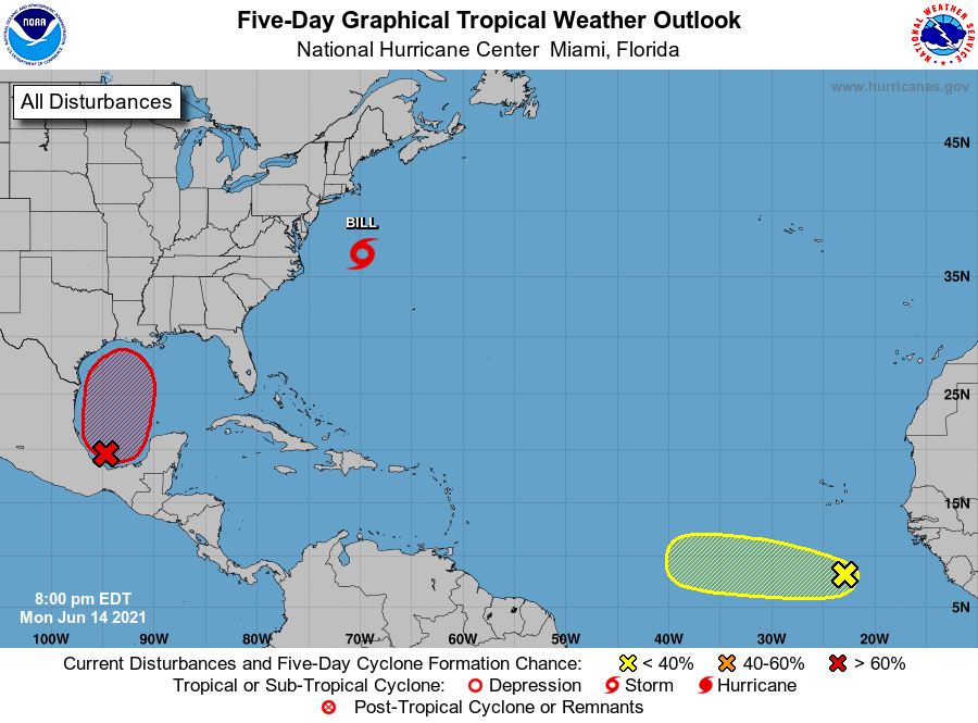
Tropical Weather Outlook
NWS National Hurricane Center Miami FL
800 PM EDT Mon Jun 14 2021
For the North Atlantic...Caribbean Sea and the Gulf of Mexico:
The National Hurricane Center is issuing advisories on Tropical
Depression Two, located about a couple of hundred miles east of
Cape Hatteras, North Carolina.
1. Disorganized showers and thunderstorms continue over the Bay of
Campeche in association with a broad low pressure area. Gradual
development of this disturbance is possible during the next couple
of days while it meanders near the coast of Mexico. The system
should begin to move northward by midweek, and a tropical depression
is likely to form late in the week when the low moves across the
central or northwestern Gulf of Mexico. Regardless of development,
heavy rainfall is possible over portions of Central America and
southern Mexico during the next several days. Heavy rains could
also begin to impact portions of the northern Gulf Coast on Friday.
Please consult products from your local meteorological service for
more information.
* Formation chance through 48 hours...low...20 percent.
* Formation chance through 5 days...high...70 percent.
2. A strong tropical wave located several hundred miles south of the
Cabo Verde Islands is producing a large area of cloudiness and a few
showers and thunderstorms. Some development of this system is
possible during the next few days before a combination of dry air
aloft and strong upper-level winds limit any chance of formation
while the wave is over the central tropical Atlantic Ocean late this
week.
* Formation chance through 48 hours...low...10 percent.
* Formation chance through 5 days...low...20 percent.
Public Advisories on Tropical Depression Two are issued under WMO
header WTNT32 KNHC and under AWIPS header MIATCPAT2.
Forecast/Advisories on Tropical Depression Two are issued under WMO
header WTNT22 KNHC and under AWIPS header MIATCMAT2.
Forecaster Pasch