ZCZC MIATWOAT ALL
TTAA00 KNHC DDHHMM
Special Tropical Weather Outlook
NWS National Hurricane Center Miami FL
500 AM EDT Mon Jun 14 2021
For the North Atlantic...Caribbean Sea and the Gulf of Mexico:
Special tropical weather outlook issued to update the discussion of
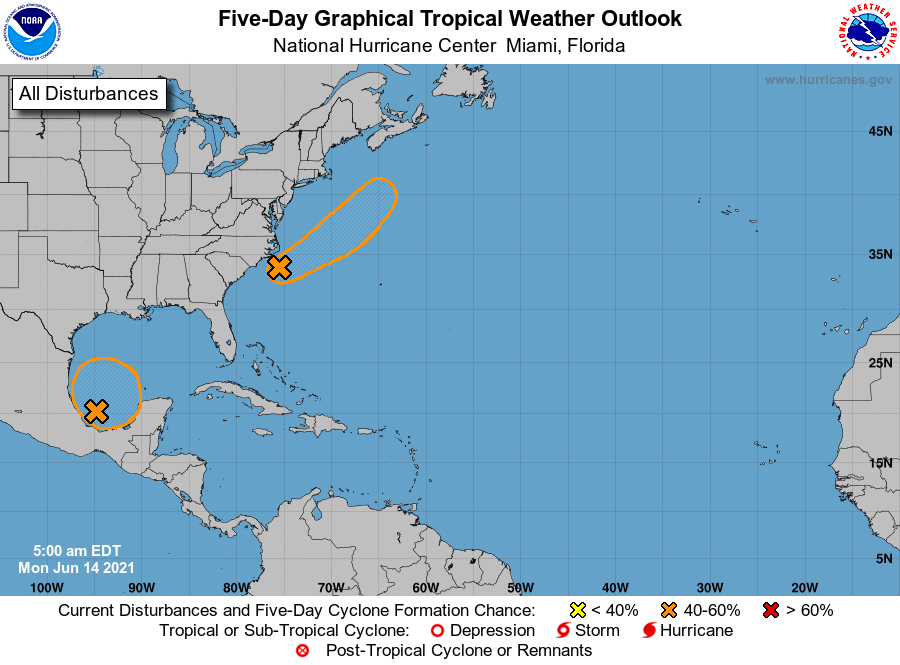
the low-pressure system offshore the North Carolina coast.
1. Updated: A well-defined, non-tropical low pressure system is
located about 120 miles south of Cape Hatteras, North Carolina.
Satellite and radar data indicate that thunderstorm activity has
continued to increase and become more concentrated near the center
of the low early this morning, and environmental conditions are
expected to be at least marginally conducive for tropical cyclone
formation. If this recent development trend continues, then a
short-lived tropical depression or tropical storm could form later
today while the system moves northeastward away from the United
States. The low will move over colder waters south of Nova Scotia
on Wednesday, ending any opportunity for further development.
* Formation chance through 48 hours...medium...50 percent.
* Formation chance through 5 days...medium...50 percent.
2. A large area of cloudiness and showers located over the Bay of
Campeche is associated with a broad low pressure area. Some slow
development of this disturbance is possible during the next few days
while it meanders near the coast of Mexico, and a tropical
depression could form late in the week when the system begins to
move slowly northward. Regardless of development, heavy rainfall is
possible over portions of Central America and southern Mexico during
the next several days. Please consult products from your local
meteorological service for more information.
* Formation chance through 48 hours...low...20 percent.
* Formation chance through 5 days...medium...50 percent.
Forecaster Stewart