ZCZC MIATWOAT ALL
TTAA00 KNHC DDHHMM
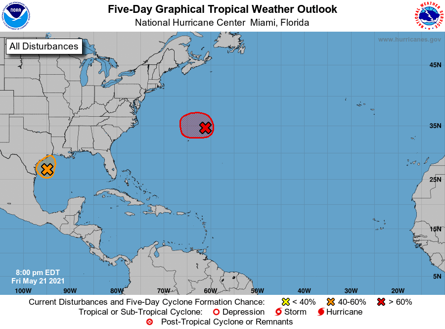
Tropical Weather Outlook
NWS National Hurricane Center Miami FL
800 PM EDT Fri May 21 2021
For the North Atlantic...Caribbean Sea and the Gulf of Mexico:
1. Recent satellite images indicate that the area of low pressure
located about 250 miles northeast of Bermuda is well-defined and is
gradually acquiring subtropical characteristics. In addition,
earlier satellite-derived wind data revealed that the system is
producing gale-force winds. The associated shower and thunderstorm
activity has increased slightly over the past several hours. If that
trend continues, it would result in advisories being initiated on
the system later tonight or Saturday morning while it moves slowly
westward to west-southwestward to the northeast of Bermuda. The
low is forecast to move northeastward into a more hostile
environment by Saturday night or Sunday and the system’s development
chances diminish after that time. Additional information on this
low pressure area can be found in High Seas forecasts issued by the
NOAA Ocean Prediction Center and forecast products, including a
tropical storm watch, issued by the Bermuda Weather Service.
* Formation chance through 48 hours...high...90 percent.
* Formation chance through 5 days...high...90 percent.
2. A well-defined low pressure area is located over the western Gulf of
Mexico about 150 miles east-southeast of Corpus Christi, Texas.
Earlier satellite wind data and buoy observations indicated that the
system is producing winds of 30-35 mph near and to the east of its
center but recent satellite and radar imagery shows that shower and
thunderstorm activity remains limited. Although environmental
conditions are not particularly favorable for significant
development, only a slight increase in thunderstorm activity could
result in the formation of a tropical depression or storm before the
system moves inland along the Texas coast overnight. Regardless of
development, the system could produce heavy rainfall over portions
of southeastern Texas and southwestern Louisiana through Saturday.
Given the complete saturation of soils with ongoing river flooding
along the Texas and Louisiana coastal areas, heavy rain could lead
to flash, urban, and additional riverine flooding across this
region. Additional information on the rainfall and flooding
potential can be found in products issued by your local National
Weather Service Forecast Office.
* Formation chance through 48 hours...medium...50 percent.
* Formation chance through 5 days...medium...50 percent.
High Seas Forecasts issued by the National Weather Service can be
found under AWIPS header NFDHSFAT1, WMO header FZNT01 KWBC, and
online at ocean.weather.gov/shtml/NFDHSFAT1.php
Forecaster Latto/Brown