ZCZC MIATWOAT ALL
TTAA00 KNHC DDHHMM
Tropical Weather Outlook
NWS National Hurricane Center Miami FL
800 PM EDT Thu May 20 2021
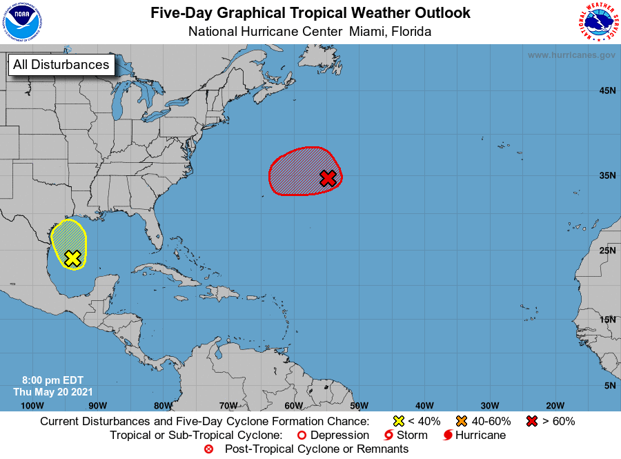
For the North Atlantic...Caribbean Sea and the Gulf of Mexico:
1. A non-tropical low pressure area located about 625 miles east-
northeast of Bermuda is forecast to strengthen into a storm-force
low pressure system tonight. On Friday, the low is expected to turn
west-southwestward over warmer waters and will likely become a
subtropical cyclone near and to the northeast of Bermuda. After
that time, the low is forecast to move northward and northeastward
into a more hostile environment by Saturday night or Sunday.
Additional information on this developing low pressure area can be
found in High Seas forecasts issued by the NOAA Ocean Prediction
Center and forecast products, including a tropical storm watch,
issued by the Bermuda Weather Service.
* Formation chance through 48 hours...high...80 percent.
* Formation chance through 5 days...high...80 percent.
2. A disorganized area of cloudiness and thunderstorms over the
western Gulf of Mexico is associated with a surface trough of low
pressure. Conditions are expected to be marginally conducive for
some development over the next day or so before the disturbance
moves inland over the northwestern Gulf coast late Friday or Friday
night. Regardless of development, the system could produce heavy
rainfall over portions of southeastern Texas and southwestern
Louisiana on Friday and through the weekend. Additional information
on the rainfall and flooding potential can be found in products
issued by your local National Weather Service Forecast Office.
* Formation chance through 48 hours...low...20 percent.
* Formation chance through 5 days...low...20 percent.
High Seas Forecasts issued by the National Weather Service can be
found under AWIPS header NFDHSFAT1, WMO header FZNT01 KWBC, and
online at ocean.weather.gov/shtml/NFDHSFAT1.php
Forecaster Latto/Brown