ZCZC MIATWOAT ALL
TTAA00 KNHC DDHHMM
Tropical Weather Outlook
NWS National Hurricane Center Miami FL
800 PM EDT Wed Oct 14 2020
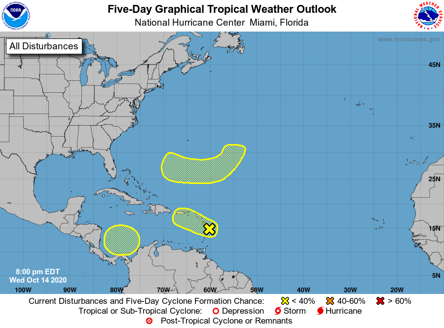
For the North Atlantic...Caribbean Sea and the Gulf of Mexico:
1. A broad area of low pressure near the Lesser Antilles continues to
produce a large area of disorganized showers and thunderstorms,
mainly to the east of its center. Strong upper-level winds are
expected to inhibit significant development while the system moves
west-northwestward over the next couple of days. Regardless of
development, the system could produce locally heavy rainfall and
gusty winds across portions of the Lesser Antilles tonight and
Thursday morning, the Virgin Islands, Puerto Rico, and the eastern
Caribbean Sea late Thursday into Friday, and Hispaniola Friday
night into Saturday.
* Formation chance through 48 hours...low...10 percent.
* Formation chance through 5 days...low...10 percent.
2. A broad non-tropical low pressure system is expected to form over
the weekend several hundred miles southeast of Bermuda. Some slow
development will be possible thereafter into early next week
while the system moves southwestward and then westward, passing
about midway between Bermuda and the northern Lesser Antilles.
* Formation chance through 48 hours...low...near 0 percent.
* Formation chance through 5 days...low...20 percent.
3. A broad area of low pressure could form by early next week over
the southwestern Caribbean Sea. Some gradual development of the
system will be possible thereafter while it moves slowly
west-northwestward.
* Formation chance through 48 hours...low...near 0 percent.
* Formation chance through 5 days...low...20 percent.
Forecaster Stewart