ZCZC MIATWOAT ALL
TTAA00 KNHC DDHHMM
Tropical Weather Outlook
NWS National Hurricane Center Miami FL
200 PM EDT Sun Oct 4 2020
For the North Atlantic...Caribbean Sea and the Gulf of Mexico:
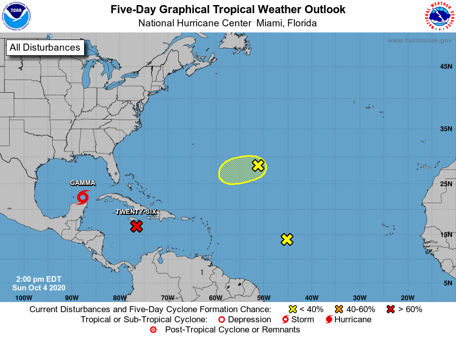
The National Hurricane Center is issuing advisories on Tropical
Storm Gamma, located just north of the Yucatan Peninsula over the
extreme southern Gulf of Mexico.
1. A broad area of low pressure is located over the central Caribbean
Sea, a little less than 100 miles south-southeast of eastern
Jamaica. Recent satellite wind data and visible satellite imagery
indicate that the circulation is gradually becoming better defined,
however, the associated shower and thunderstorm activity has
changed little in organization since this morning. Environmental
conditions are expected to be conducive for additional development,
and a tropical depression is likely to form within the next day or
so, while the system moves over the central and northwestern
Caribbean Sea. The disturbance is forecast to move near Jamaica
through Monday, and then pass near the Cayman Islands early Tuesday
and approach western Cuba by late Tuesday, and interests in those
areas should closely monitor the progress of this system. The low
is forecast to move into the southern or southeastern Gulf of
Mexico Tuesday night or Wednesday. Regardless of development,
locally heavy rainfall and gusty winds will be possible across
portions of Hispaniola, Jamaica, the Cayman Islands, and Cuba
during the next few days. This rainfall could lead to
life-threatening flash floods and mudslides.
* Formation chance through 48 hours...high...80 percent.
* Formation chance through 5 days...high...80 percent.
2. Showers and thunderstorms associated with a tropical wave over the
central tropical Atlantic have become limited today. The system is
moving into an area of strong upper-level winds and development of
this system is not anticipated.
* Formation chance through 48 hours...low...near 0 percent.
* Formation chance through 5 days...low...near 0 percent.
3. An area of disorganized showers and thunderstorms over the central
Atlantic about 1000 miles east-southeast of Bermuda is associated
with a surface trough of low pressure. This system is expected to
move toward the west-southwest at around 10 mph, and some slow
development is possible during the next couple of days before it
encounters strong upper-level winds.
* Formation chance through 48 hours...low...10 percent.
* Formation chance through 5 days...low...10 percent.
Forecaster Brown