ZCZC MIATWOAT ALL
TTAA00 KNHC DDHHMM
Tropical Weather Outlook
NWS National Hurricane Center Miami FL
200 PM EDT Sat Oct 3 2020
For the North Atlantic...Caribbean Sea and the Gulf of Mexico:
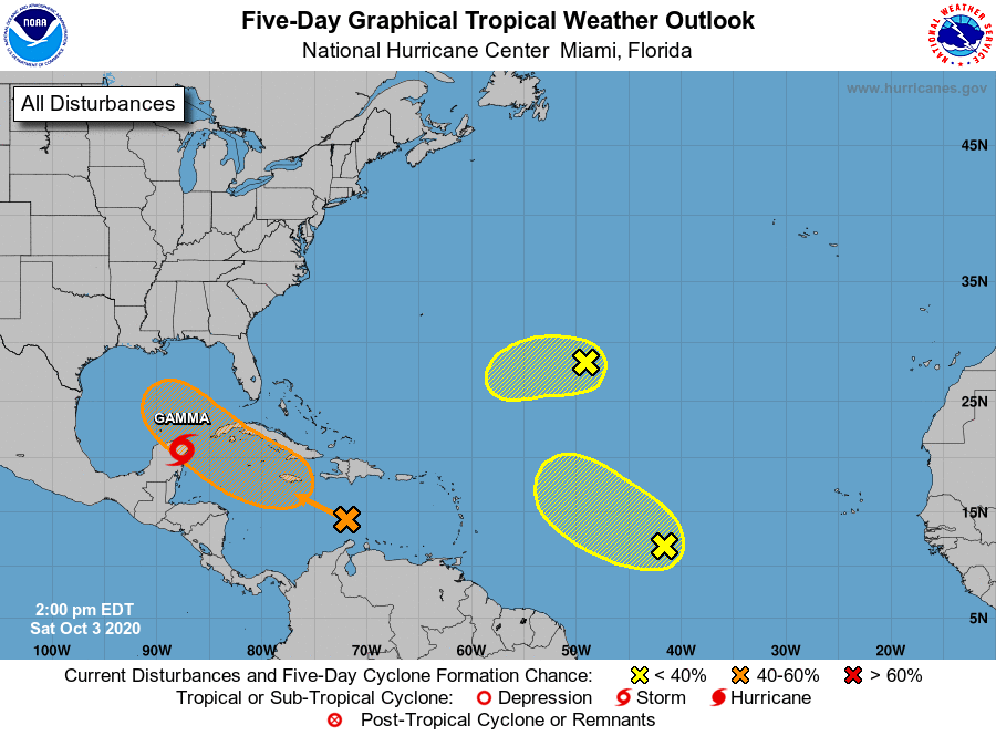
The National Hurricane Center is issuing advisories on Tropical
Storm Gamma, located inland over the Yucatan Peninsula.
1. Shower and thunderstorm activity has become more consolidated since
yesterday near a tropical wave located over the central Caribbean
Sea. Environmental conditions are expected to become more conducive
for development, and a tropical depression could form next week
while the system moves westward or west-northwestward at about 15
mph across the central and western Caribbean Sea and then into the
southern Gulf of Mexico. Locally heavy rainfall and gusty winds
will be possible across portions of Hispaniola, Jamaica, Cuba, and
the Cayman Islands during the next few days, and interests on those
islands should monitor the progress of this disturbance.
* Formation chance through 48 hours...low...30 percent.
* Formation chance through 5 days...medium...60 percent.
2. A tropical wave located over the central tropical Atlantic is
producing disorganized showers and thunderstorms. This system
is expected to move toward the west-northwest or northwest at 10 to
15 mph, and some development is possible during the next couple of
days before it encounters strong upper-level winds.
* Formation chance through 48 hours...low...20 percent.
* Formation chance through 5 days...low...20 percent.
3. An area of disorganized showers and thunderstorms over the central
Atlantic more than 1000 miles east-southeast of Bermuda is
associated with a surface trough of low pressure. This system
is expected to move toward the west-southwest at around 10 mph,
and some slow development is possible during the next couple of
days before it too encounters strong upper-level winds.
* Formation chance through 48 hours...low...10 percent.
* Formation chance through 5 days...low...10 percent.
Forecaster Berg