ZCZC MIATWOAT ALL
TTAA00 KNHC DDHHMM
Tropical Weather Outlook
NWS National Hurricane Center Miami FL
200 PM EDT Sun Sep 20 2020
For the North Atlantic...Caribbean Sea and the Gulf of Mexico:
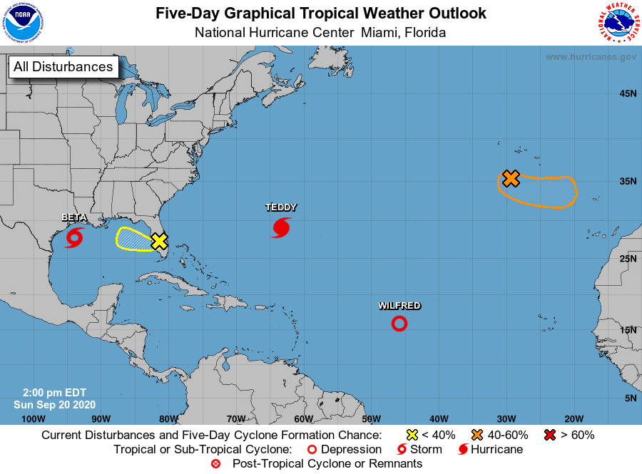
The National Hurricane Center is issuing advisories on Tropical
Storm Beta, located over the western Gulf of Mexico, on Hurricane
Teddy, located a few hundred miles south-southeast of Bermuda,
and on recently downgraded Tropical Depression Wilfred, located
over the central tropical Atlantic.
1. Post-Tropical Cyclone Paulette is located a few hundred miles south
of the Azores and continues to produce disorganized shower activity
to the northwest and north of its center of circulation. This system
is drifting southward over marginally warm waters and is expected to
begin moving eastward in a couple of days. The cyclone could develop
tropical or subtropical characteristics during the next day or two.
For more information about marine hazards associated with this
system, see High Seas Forecasts issued by Meteo France.
* Formation chance through 48 hours...medium...60 percent.
* Formation chance through 5 days...medium...60 percent.
2. A small low pressure system has moved inland over the south-central
Florida peninsula and is located just to the northwest of Lake
Okeechobee. Although shower activity is currently disorganized, some
development could occur when the low moves westward over the eastern
Gulf of Mexico later tonight and on Monday. However, by late Tuesday
or Wednesday, upper-level winds are expected to become unfavorable
for tropical cyclone formation while the system moves westward to
west-northwestward at about 10 mph. For more information on this
disturbance, please see local products and High Seas Forecasts
issued by the National Weather Service.
* Formation chance through 48 hours...low...10 percent.
* Formation chance through 5 days...low...10 percent.
High Seas Forecasts issued by Meteo France can be found under WMO
header FQNT50 LFPW and are available on the web at
www.meteofrance.com/previsions-meteo-marine/bulletin/grandlarge/
metarea2
Local forecast products issued by the National Weather Service are
available on the web at www.weather.gov.
High Seas Forecasts issued by the National Weather Service can be
found under AWIPS header NFDHSFAT1, WMO header FZNT01 KWBC, and
online at ocean.weather.gov/shtml/NFDHSFAT1.php
Forecaster Stewart