ZCZC MIATWOAT ALL
TTAA00 KNHC DDHHMM
Tropical Weather Outlook
NWS National Hurricane Center Miami FL
200 AM EDT Sun Sep 20 2020
For the North Atlantic...Caribbean Sea and the Gulf of Mexico:
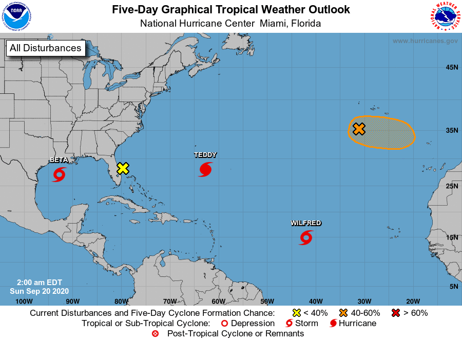
The National Hurricane Center is issuing advisories on Tropical
Storm Beta, located over the western Gulf of Mexico, on Hurricane
Teddy, located several hundred miles south-southeast of Bermuda,
and on Tropical Storm Wilfred, located over the central tropical
Atlantic.
1. Post-Tropical Cyclone Paulette is located a few hundred miles south
of the Azores and continues to produce a few showers, well to the
northeast of its center of circulation. This system is drifting
southward over marginally warm waters and is expected to begin
moving eastward in a couple of days. The cyclone could develop
tropical or subtropical characteristics during the next day or two.
For more information about marine hazards associated with this
system, see High Seas Forecasts issued by Meteo France.
* Formation chance through 48 hours...medium...60 percent.
* Formation chance through 5 days...medium...60 percent.
2. A small low pressure system is located near a frontal boundary, just
off the eastern coast of central Florida. The low is producing a
small area of thunderstorms near the coast, and recent buoy and
satellite-derived wind data indicate that gale-force winds are
occuring in the area. The low is expected to move inland over
Florida later this morning, and significant development is not
anticipated. For more information on this system, please see local
products and High Seas Forecasts issued by the National Weather
Service.
* Formation chance through 48 hours...low...10 percent.
* Formation chance through 5 days...low...10 percent.
High Seas Forecasts issued by Meteo France can be found under WMO
header FQNT50 LFPW and are available on the web at
www.meteofrance.com/previsions-meteo-marine/bulletin/grandlarge/
metarea2
Local forecast products issued by the National Weather Service are
available on the web at www.weather.gov.
High Seas Forecasts issued by the National Weather Service can be
found under AWIPS header NFDHSFAT1, WMO header FZNT01 KWBC, and
online at ocean.weather.gov/shtml/NFDHSFAT1.php
Forecaster Zelinsky