ZCZC MIATWOAT ALL
TTAA00 KNHC DDHHMM
Tropical Weather Outlook
NWS National Hurricane Center Miami FL
800 PM EDT Thu Sep 17 2020
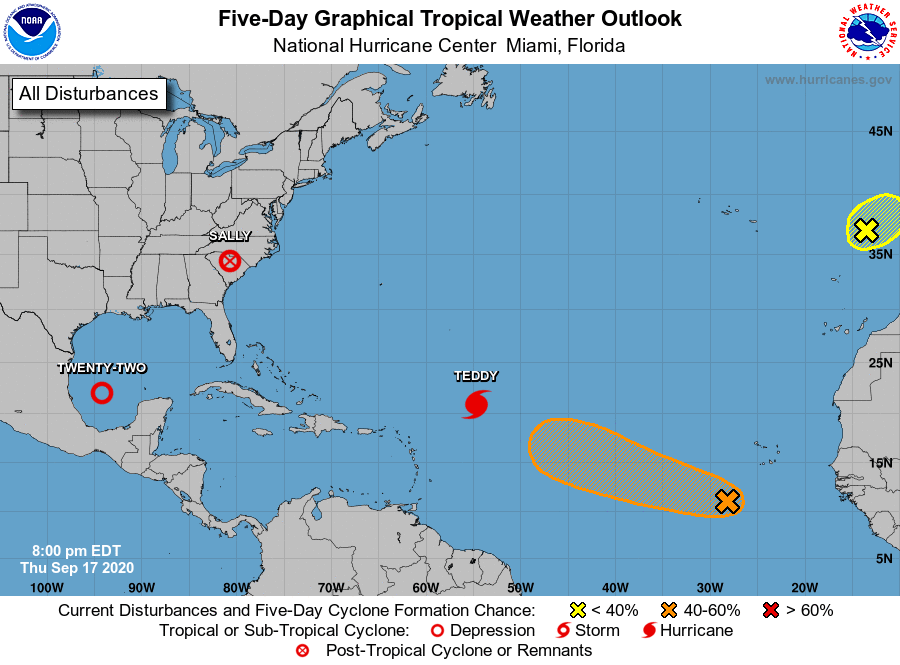
For the North Atlantic...Caribbean Sea and the Gulf of Mexico:
The National Hurricane Center is issuing advisories on Hurricane
Teddy, located over the central tropical Atlantic, and has issued
the last advisory on Vicky, which has become a remnant low over the
eastern tropical Atlantic. The National Hurricane Center has begun
issuing advisories on newly formed Tropical Depression Twenty-Two,
located over the southwestern Gulf of Mexico.
1. An elongated area of low pressure located a few hundred miles
south-southwest of the Cabo Verde Islands is producing disorganized
shower and thunderstorm activity. Environmental conditions are
expected to be conducive for development during the next few days,
and a tropical depression could form before upper-level winds become
less favorable by late this weekend. The system is forecast to move
west-northwestward at 10 to 15 mph during the next several days.
* Formation chance through 48 hours...medium...40 percent.
* Formation chance through 5 days...medium...50 percent.
2. Showers and thunderstorms have change little since this morning in
association with a non-tropical area of low pressure located over
the far northeastern Atlantic Ocean several hundred miles east of
the Azores. This system is forecast to move eastward and then
northeastward at about 10 mph, and its opportunity for subtropical
development will soon be decreasing since it is expected to reach
the coast of Portugal on Friday. For more information on this
system, see High Seas Forecasts issued by Meteo France.
* Formation chance through 48 hours...low...30 percent.
* Formation chance through 5 days...low...30 percent.
Public Advisories on Tropical Depression Twenty-Two are issued
under WMO header WTNT32 KNHC and under AWIPS header MIATCPAT2.
Forecast/Advisories on Tropical Depression Twenty-Two are issued
under WMO header WTNT22 KNHC and under AWIPS header MIATCMAT2.
High Seas Forecasts issued by Meteo France can be found under WMO
header FQNT50 LFPW and available on the web at
www.meteofrance.com/previsions-meteo-marine/bulletin/grandlarge/
metarea2
Forecaster Pasch