ZCZC MIATWOAT ALL
TTAA00 KNHC DDHHMM
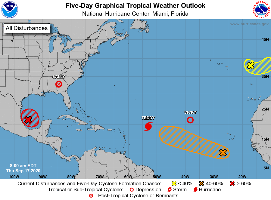
Tropical Weather Outlook
NWS National Hurricane Center Miami FL
800 AM EDT Thu Sep 17 2020
For the North Atlantic...Caribbean Sea and the Gulf of Mexico:
The National Hurricane Center is issuing advisories on Hurricane
Teddy, located over the central tropical Atlantic and on Tropical
Storm Vicky, located over the eastern tropical Atlantic. The
National Hurricane Center has issued its last advisory on Tropical
Depression Sally, located inland over eastern Alabama.
1. Thunderstorm activity has continued to increase and become better
organized this morning in association with a well-defined low
pressure system located over the southwestern Gulf of Mexico.
Upper-level winds are gradually becoming more conducive for
development and, if this recent development trend continues, a
tropical depression or a tropical storm could form later today. The
low is expected to meander over the southwestern Gulf of Mexico for
the next day or so before moving slowly northward to northeastward
on Friday and Saturday. An Air Force Reserve reconnaissance
aircraft is scheduled to investigate the disturbance this afternoon.
* Formation chance through 48 hours...high...90 percent.
* Formation chance through 5 days...high...90 percent.
2. An elongated area of low pressure located a few hundred miles
south-southwest of the Cabo Verde Islands is producing disorganized
shower and thunderstorm activity. Environmental conditions are
expected to be conducive for development during the next few days,
and a tropical depression could form before upper-level winds become
less favorable over the weekend. The low is forecast to move
west-northwestward at 10 to 15 mph during the next several days.
* Formation chance through 48 hours...medium...40 percent.
* Formation chance through 5 days...medium...50 percent.
3. Showers and thunderstorms have become more concentrated this morning
in association with a non-tropical area of low pressure located
over the far northeastern Atlantic Ocean several hundred miles east
of the Azores. Some additional subtropical development is possible
over the next day or so as it moves east-southeastward and then
northeastward at about 10 mph. The system is expected to reach the
coast of Portugal late Friday. For more information on this system,
see High Seas Forecasts issued by Meteo France.
* Formation chance through 48 hours...low...30 percent.
* Formation chance through 5 days...low...30 percent.
High Seas Forecasts issued by Meteo France can be found under WMO
header FQNT50 LFPW and available on the web at
www.meteofrance.com/previsions-meteo-marine/bulletin/grandlarge/
metarea2
Forecaster Latto