ZCZC MIATWOAT ALL
TTAA00 KNHC DDHHMM
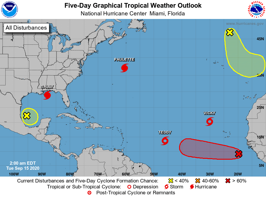
Tropical Weather Outlook
NWS National Hurricane Center Miami FL
200 AM EDT Tue Sep 15 2020
For the North Atlantic...Caribbean Sea and the Gulf of Mexico:
The National Hurricane Center is issuing advisories on Hurricane
Paulette, located several hundred miles north-northeast of Bermuda,
on Hurricane Sally, centered over the north-central Gulf of Mexico,
on Tropical Storm Teddy, located over the central tropical
Atlantic, and on Tropical Storm Vicky, located over the eastern
tropical Atlantic.
1. A broad area of low pressure over the southwestern Gulf of Mexico is
producing little shower or thunderstorm activity. Any development
of this system should be slow to occur while the low meanders over
the southern Gulf of Mexico for the next several days.
* Formation chance through 48 hours...low...10 percent.
* Formation chance through 5 days...low...20 percent.
2. An area of low pressure has formed from a low-latitude tropical
wave located a few hundred miles south-southeast of the Cabo Verde
Islands. Shower and thunderstorm activity has become more
concentrated during the past several hours, and a tropical
depression is likely to form during the next few days while the
system moves generally westward at 10 to 15 mph.
* Formation chance through 48 hours...medium...50 percent.
* Formation chance through 5 days...high...70 percent.
3. A non-tropical area of low pressure is located over the far
northeastern Atlantic Ocean several hundred miles northeast of the
Azores. This system is forecast to move south-southeastward during
the next few days where it will encounter warmer waters, which
could allow the low to gradually acquire some tropical or
subtropical characteristics this week.
* Formation chance through 48 hours...low...10 percent.
* Formation chance through 5 days...low...20 percent.
Public Advisories on Tropical Storm Vicky are issued under WMO
header WTNT31 KNHC and under AWIPS header MIATCPAT1.
Forecast/Advisories on Tropical Storm Vicky are issued under WMO
header WTNT21 KNHC and under AWIPS header MIATCMAT1.
Forecaster Blake