ZCZC MIATWOAT ALL
TTAA00 KNHC DDHHMM
Tropical Weather Outlook
NWS National Hurricane Center Miami FL
200 AM EDT Mon Sep 14 2020
For the North Atlantic...Caribbean Sea and the Gulf of Mexico:
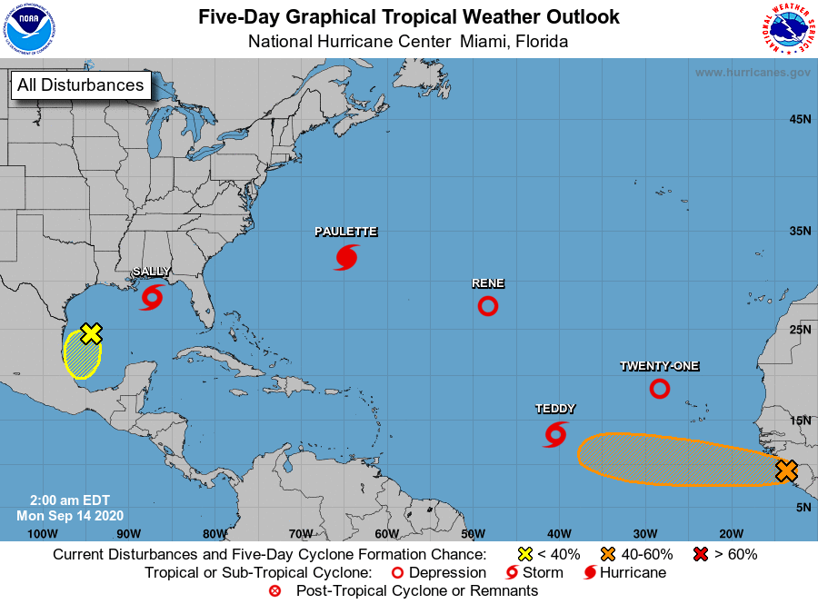
The National Hurricane Center is issuing advisories on Hurricane
Paulette, located near Bermuda, on Tropical Depression Rene,
located over the central Atlantic, on Tropical Storm Sally,
centered over the north-central Gulf of Mexico, and on Tropical
Depression Twenty, located over the east-central tropical Atlantic.
1. A weak area of low pressure over the west-central Gulf of Mexico
continues to produce limited shower activity. Development of this
system is not expected due to strong upper-level winds while it
moves slowly southwestward and then southward over the western Gulf
of Mexico during the next few days.
* Formation chance through 48 hours...low...near 0 percent.
* Formation chance through 5 days...low...10 percent.
2. An elongated area of low pressure located a couple of hundred miles
west-northwest of the Cabo Verde Islands continues to produce an
area of showers and thunderstorms. Environmental conditions are
conducive for a short-lived tropical depression to form on Monday
while the low moves north-northwestward at 5 to 10 mph. Development
is not expected by Tuesday when the system is forecast to encounter
strong upper-level winds and move over colder waters.
* Formation chance through 48 hours...high...70 percent.
* Formation chance through 5 days...high...70 percent.
3. A tropical wave near the west coast of Africa is producing
disorganized shower and thunderstorm activity. Environmental
conditions appear to be conducive for slow development of the
system this week as the wave moves westward at about 10 mph over
the far eastern tropical Atlantic.
* Formation chance through 48 hours...low...10 percent.
* Formation chance through 5 days...medium...40 percent.
Forecaster Blake