ZCZC MIATWOAT ALL
TTAA00 KNHC DDHHMM
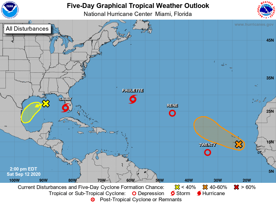
Tropical Weather Outlook
NWS National Hurricane Center Miami FL
200 PM EDT Sat Sep 12 2020
For the North Atlantic...Caribbean Sea and the Gulf of Mexico:
The National Hurricane Center is issuing advisories on Tropical
Storm Paulette and Tropical Depression Rene, both located over the
central Atlantic Ocean. The National Hurricane Center is also
issuing advisories on recently upgraded Tropical Storm Sally,
located near southern Florida.
1. A surface trough over the north-central Gulf of Mexico is producing
disorganized showers and a few thunderstorms. Some slow
development of this system is possible while it moves westward and
then southwestward over the northern and western Gulf of Mexico
through the middle of next week.
* Formation chance through 48 hours...low...20 percent.
* Formation chance through 5 days...low...30 percent.
2. Satellite imagery and satellite-derived wind data indicate that the
area of low pressure located several hundred miles west-southwest of
the Cabo Verde Islands has become better defined. The associated
shower and thunderstorm activity is also becoming better organized.
If this development trend continues, then a tropical depression
will likely form later today or tonight. The system is expected to
move westward then northwestward across the eastern and central
tropical Atlantic over the next several days.
* Formation chance through 48 hours...high...90 percent.
* Formation chance through 5 days...high...90 percent.
3. Showers and thunderstorms located near the Cabo Verde Islands are
associated with a broad area of low pressure that has developed
along a tropical wave. Environmental conditions support some
additional development during the next few days, and a tropical
depression could form over the far eastern tropical Atlantic early
next week while the system moves slowly west-northwestward. By
mid-week, upper-level winds could become less conducive for
development.
* Formation chance through 48 hours...medium...40 percent.
* Formation chance through 5 days...medium...60 percent.
Public Advisories on Sally are issued under WMO header WTNT34 KNHC
and under AWIPS header MIATCPAT4. Forecast/Advisories on Sally
are issued under WMO header WTNT24 KNHC and under AWIPS header
MIATCMAT4.
Forecaster Latto