ZCZC MIATWOAT ALL
TTAA00 KNHC DDHHMM
Tropical Weather Outlook
NWS National Hurricane Center Miami FL
800 PM EDT Fri Sep 11 2020
For the North Atlantic...Caribbean Sea and the Gulf of Mexico:
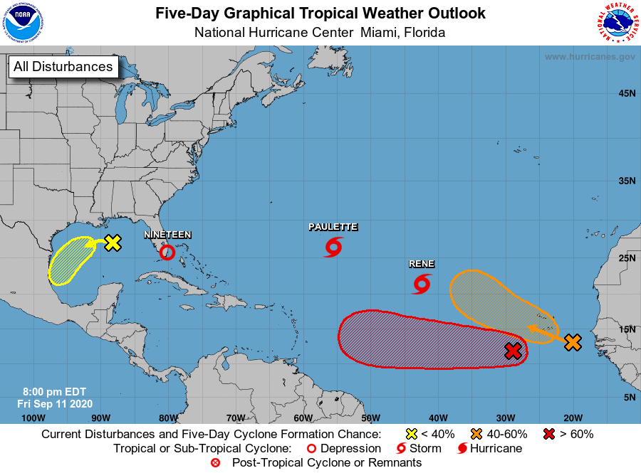
The National Hurricane Center is issuing advisories on Tropical
Storm Paulette and Tropical Storm Rene, both located over the
central Atlantic Ocean. The National Hurricane Center is also
issuing advisories on newly formed Tropical Depression Nineteen,
located near southern Florida.
1. A surface trough over the north-central Gulf of Mexico is producing
disorganized showers and a few thunderstorms. Some slow
development of this system is possible while it moves
westward and then southwestward over the northern and western Gulf
of Mexico through the middle of next week.
* Formation chance through 48 hours...low...20 percent.
* Formation chance through 5 days...low...30 percent.
2. A broad area of low pressure located a few hundred miles
south-southwest of the Cabo Verde Islands is producing a large
area of disorganized showers and thunderstorms. Development of
this system is forecast, and a tropical depression is expected to
form within the next couple of days while the system moves
generally westward at 15 to 20 mph across the eastern and central
tropical Atlantic.
* Formation chance through 48 hours...high...80 percent.
* Formation chance through 5 days...high...90 percent.
3. Another area of disturbed weather, associated with a tropical wave,
is located just off of the west coast of Africa. Environmental
conditions could support development during the next few days, and
a tropical depression could form over the far eastern tropical
Atlantic early next week while the system moves slowly westward.
Upper-level winds could become less conducive for development by
Tuesday.
* Formation chance through 48 hours...low...10 percent.
* Formation chance through 5 days...medium...40 percent.
Public Advisories on Tropical Depression Nineteen are issued under
WMO header WTNT34 KNHC and under AWIPS header MIATCPAT4.
Forecast/Advisories on Tropical Depression Nineteen are issued
under WMO header WTNT24 KNHC and under AWIPS header MIATCMAT4.
Forecaster Cangialosi