ZCZC MIATWOAT ALL
TTAA00 KNHC DDHHMM
Tropical Weather Outlook
NWS National Hurricane Center Miami FL
200 AM EDT Thu Sep 10 2020
For the North Atlantic...Caribbean Sea and the Gulf of Mexico:
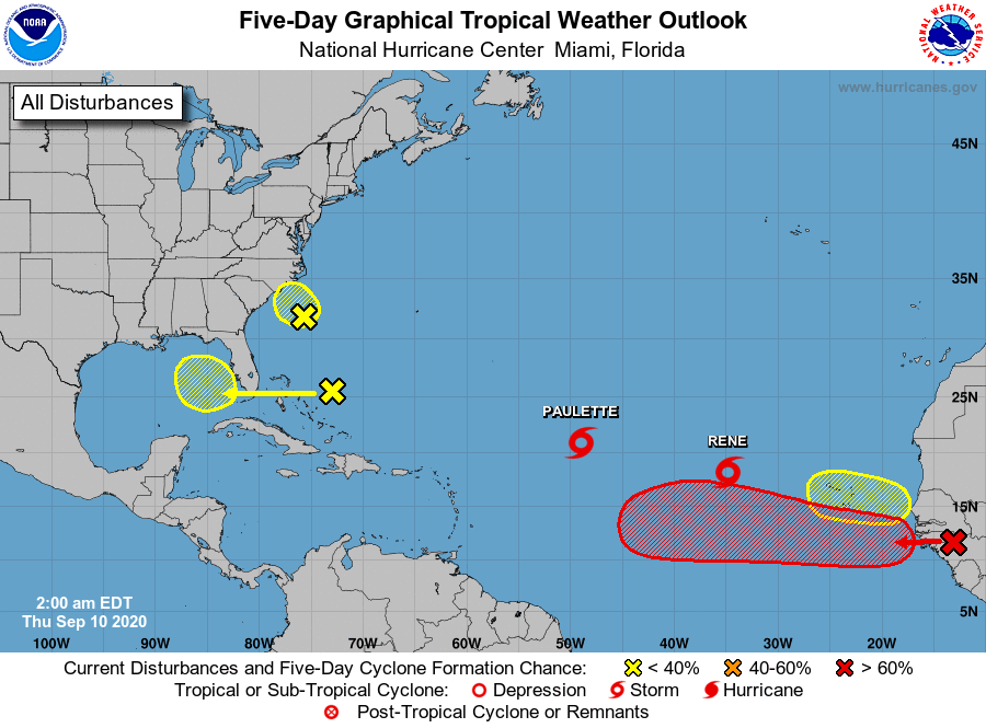
The National Hurricane Center is issuing advisories on Tropical
Storm Paulette, located over the central tropical Atlantic, and on
Tropical Storm Rene, located over the eastern tropical Atlantic.
1. Satellite wind data and surface observations indicate that the low
pressure area of of the coast of the Carolinas has weakened to a
trough. The system is forecast to move northwestward at 10 to 15
mph and move inland over eastern North Carolina this afternoon,
and the chances for significant development by that time are
decreasing. Interests along the coasts of North and South Carolina
should continue to monitor the progress of this disturbance.
* Formation chance through 48 hours...low...10 percent.
* Formation chance through 5 days...low...10 percent.
2. A large area of disorganized showers and thunderstorm is centered a
couple of hundred miles northeast of the Central Bahamas. This
system is forecast to drift westward and will likely be in the
vicinity of the Florida peninsula on Friday. Afterward, upper-level
conditions could become conducive for some development this weekend
while the system drifts west-northwestward over the eastern Gulf of
Mexico.
* Formation chance through 48 hours...low...near 0 percent.
* Formation chance through 5 days...low...20 percent.
3. A tropical wave is forecast to move off the west coast of Africa
later today. Gradual development is anticipated once the system
moves over water, and a tropical depression is expected to form
late this week or over the weekend while the system moves generally
westward across the eastern tropical Atlantic.
* Formation chance through 48 hours...medium...60 percent.
* Formation chance through 5 days...high...90 percent.
4. Another tropical wave is forecast to emerge off the west coast of
Africa this weekend. Environmental conditions could be conducive
for slow development over the far eastern tropical Atlantic Ocean
early next week while the wave moves slowly westward.
* Formation chance through 48 hours...low...near 0 percent.
* Formation chance through 5 days...low...30 percent.
Forecaster Beven