ZCZC MIATWOAT ALL
TTAA00 KNHC DDHHMM
Tropical Weather Outlook
NWS National Hurricane Center Miami FL
200 AM EDT Mon Sep 7 2020
For the North Atlantic...Caribbean Sea and the Gulf of Mexico:
The National Hurricane Center is issuing advisories on newly formed
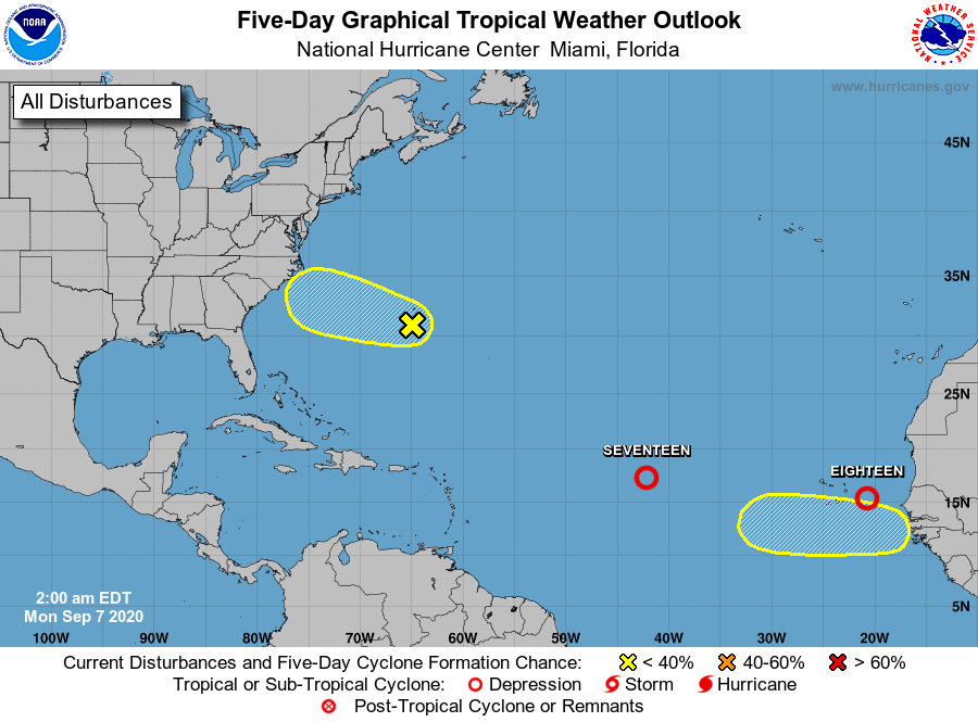
Tropical Depression Seventeen, located over the central tropical
Atlantic.
1. Showers and thunderstorms associated with an area of low pressure
located between the west coast of Africa and the Cabo Verde Islands
are showing signs of organization. Environmental conditions are
conducive for additional development, and a tropical depression is
likely to form today while the system moves generally westward
toward the Cabo Verde Islands. Interests in those islands should
monitor the progress of this system as gusty winds and locally heavy
rainfall are likely to begin spreading over the area later today.
A Tropical Storm Watch or Warning could be required for the Cabo
Verde Islands later this morning.
* Formation chance through 48 hours...high...90 percent.
* Formation chance through 5 days...high...90 percent.
2. A trough of low pressure located just south-southwest of Bermuda is
producing disorganized cloudiness and showers. Some slow
development of this system is possible this week while it moves
west-northwestward.
* Formation chance through 48 hours...low...10 percent.
* Formation chance through 5 days...low...30 percent.
3. A new tropical wave is forecast to emerge off the west coast of
Africa by the middle to latter part of this week. Some gradual
development will be possible thereafter while the system moves
generally westward.
* Formation chance through 48 hours...low...near 0 percent.
* Formation chance through 5 days...low...30 percent.
Public Advisories on Tropical Depression Seventeen are issued under
WMO header WTNT32 KNHC and under AWIPS header MIATCPAT2.
Forecast/Advisories on Tropical Depression Seventeen are issued
under WMO header WTNT22 KNHC and under AWIPS header MIATCMAT2.
Forecaster Latto/Brown