ZCZC MIATWOAT ALL
TTAA00 KNHC DDHHMM
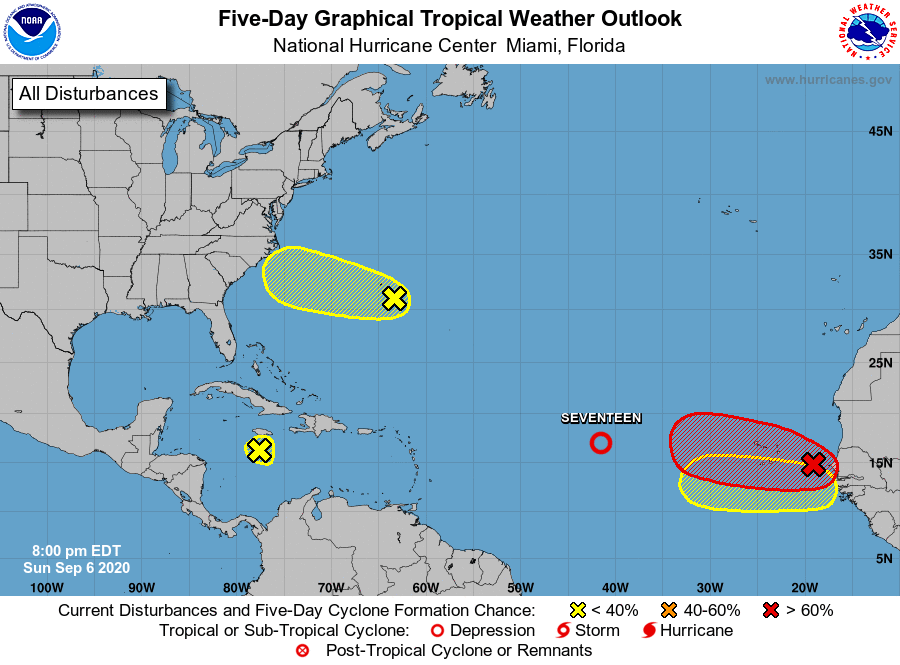
Tropical Weather Outlook
NWS National Hurricane Center Miami FL
800 PM EDT Sun Sep 6 2020
For the North Atlantic...Caribbean Sea and the Gulf of Mexico:
1. Thunderstorm activity associated with a well-defined low pressure
system located about midway between the west coast of Africa and the
northern Leeward Islands continues to get better organized. A
tropical depression is expected to form later tonight or on Monday
while the low moves westward or west-northwestward across the
central tropical Atlantic.
* Formation chance through 48 hours...high...near 100 percent.
* Formation chance through 5 days...high...near 100 percent.
2. Showers and thunderstorms continue to steadily increase and are
showing signs of organization in association with a low pressure
system located just west of Senegal. Environmental conditions
are conducive for development, and a tropical depression is
expected to form within the next day or so while the system moves
generally westward over the far eastern tropical Atlantic. Interests
in the Cabo Verde Islands should monitor the progress of this system
as gusty winds and locally heavy rainfall are likely there Monday
night and Tuesday. A Tropical Storm Watch or Warning could be
required for the islands by early Monday.
* Formation chance through 48 hours...high...90 percent.
* Formation chance through 5 days...high...90 percent.
3. A tropical wave located over the central Caribbean Sea south of
Jamaica and extending northward across the island is producing
limited shower and thunderstorm activity. Upper-level winds are
forecast to remain unfavorable for development for the next several
days while the system moves westward, and tropical cyclone formation
is not expected.
* Formation chance through 48 hours...low...near 0 percent.
* Formation chance through 5 days...low...near 0 percent.
4. A trough of low pressure located just to the southeast of Bermuda
is producing disorganized cloudiness and showers. Some slow
development of this system is possible during the next several days
while it moves west-northwestward.
* Formation chance through 48 hours...low...10 percent.
* Formation chance through 5 days...low...30 percent.
5. A new tropical wave is forecast to emerge off the west coast of
Africa by the middle to latter part of this week. Some gradual
development will be possible thereafter while the system moves
generally westward.
* Formation chance through 48 hours...low...near 0 percent.
* Formation chance through 5 days...low...20 percent.
Forecaster Stewart