ZCZC MIATWOAT ALL
TTAA00 KNHC DDHHMM
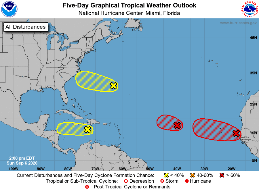
Tropical Weather Outlook
NWS National Hurricane Center Miami FL
200 PM EDT Sun Sep 6 2020
For the North Atlantic...Caribbean Sea and the Gulf of Mexico:
1. An area of low pressure located about midway between the west coast
of Africa and the Leeward Islands is gradually becoming better
defined. However, the associated showers and thunderstorms are
still not well organized. Gradual development of this system is
expected, and a tropical depression is likely to form tonight or on
Monday while it moves westward or west-northwestward across the
central tropical Atlantic.
* Formation chance through 48 hours...high...90 percent.
* Formation chance through 5 days...high...90 percent.
2. Showers and thunderstorms are showing signs of organization in
association with a broad area of low pressure located just
off the coast of western Africa. Environmental conditions
are conducive for development, and a tropical depression is
expected to form within the next couple of days while it moves
generally westward over the far eastern tropical Atlantic. Interests
in the Cabo Verde Islands should monitor the progress of this system
as gusty winds and locally heavy rainfall is likely there Monday
night and Tuesday.
* Formation chance through 48 hours...high...70 percent.
* Formation chance through 5 days...high...90 percent.
3. A tropical wave located over the central Caribbean Sea continues to
produce disorganized showers and thunderstorms. Development, if
any, of this system should be slow to occur during the next day or
two while it moves westward across the central and western
Caribbean Sea. After that time, unfavorable upper-level winds
should limit its formation chances.
* Formation chance through 48 hours...low...10 percent.
* Formation chance through 5 days...low...10 percent.
4. A trough of low pressure located just southeast of Bermuda is
producing disorganized cloudiness and showers. Some slow
development of this system is possible during the next several days
while it moves west-northwestward.
* Formation chance through 48 hours...low...10 percent.
* Formation chance through 5 days...low...30 percent.
Forecaster Cangialosi