ZCZC MIATWOAT ALL
TTAA00 KNHC DDHHMM
Tropical Weather Outlook
NWS National Hurricane Center Miami FL
800 AM EDT Sat Sep 5 2020
For the North Atlantic...Caribbean Sea and the Gulf of Mexico:
The National Hurricane Center is issuing advisories on Tropical
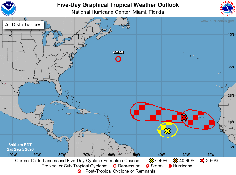
Depression Omar, located about 500 miles east-northeast of Bermuda.
1. Shower activity has become less organized in association with a
trough of low pressure located about midway between the west coast
of Africa and the Windward Islands. Significant development
of this system is not expected, as it will likely be hindered by
the interaction with a large tropical wave located a few hundred
miles to its east.
* Formation chance through 48 hours...low...10 percent.
* Formation chance through 5 days...low...10 percent.
2. A tropical wave and area of low pressure located over the eastern
tropical Atlantic continues to produce a large area of
disorganized showers and thunderstorms. Gradual development of
this system is expected while it moves westward to
west-northwestward, and a tropical depression is likely to form late
this weekend or early next week when the system reaches the central
tropical Atlantic.
* Formation chance through 48 hours...medium...50 percent.
* Formation chance through 5 days...high...90 percent.
3. Another tropical wave is forecast to move off the west coast of
Africa on Sunday. Gradual development of this system is then
expected, and a tropical depression is likely to form by the middle
of next week while it moves generally westward over the far eastern
tropical Atlantic.
* Formation chance through 48 hours...low...10 percent.
* Formation chance through 5 days...high...70 percent.
Forecaster Cangialosi