ZCZC MIATWOAT ALL
TTAA00 KNHC DDHHMM
Tropical Weather Outlook
NWS National Hurricane Center Miami FL
800 PM EDT Thu Sep 3 2020
For the North Atlantic...Caribbean Sea and the Gulf of Mexico:
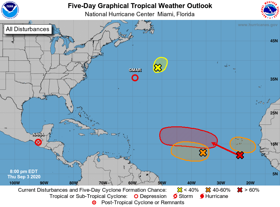
The National Hurricane Center is issuing advisories on Tropical
Depression Nana, inland near the Guatemala-Mexico border, and on
Tropical Depression Omar, located about 400 hundred miles northeast
of Bermuda.
1. Shower activity has increased today in association with a
non-tropical area of low pressure located over the north-central
Atlantic, about 625 miles south of Cape Race Newfoundland. Some
slight subtropical or tropical development of this system is
possible before it reaches cooler waters later on Friday.
* Formation chance through 48 hours...low...20 percent.
* Formation chance through 5 days...low...20 percent.
2. A broad area of low pressure located over the eastern tropical
Atlantic several hundred miles west-southwest of the Cabo Verde
Islands is producing a small area of disorganized showers and
thunderstorms. Gradual development is possible early next week once
the larger tropical wave located off of the coast of Africa passes
to the north of the system on Sunday.
* Formation chance through 48 hours...low...20 percent.
* Formation chance through 5 days...medium...40 percent.
3. A tropical wave located off the coast of west Africa is merging with
another disturbance located a couple of hundred miles south of the
Cabo Verde Islands, resulting in an extensive area of disorganized
showers and thunderstorms. Development of this system is expected
to be slow during the next couple of days while it moves west-
northwestward at about 15 mph. After that, a tropical depression is
more likely to form early next week over the central tropical
Atlantic where environmental conditions are forecast to be more
favorable for development.
* Formation chance through 48 hours...low...20 percent.
* Formation chance through 5 days...high...70 percent.
4. Another tropical wave is forecast to move off the west coast of
Africa over the weekend. An area of low pressure is expected to
form from the wave early next week. Gradual development of this low
is then expected, and a tropical depression could form while it
moves generally westward over the far eastern tropical Atlantic.
* Formation chance through 48 hours...low...near 0 percent.
* Formation chance through 5 days...medium...40 percent.
Forecaster Latto