ZCZC MIATWOAT ALL
TTAA00 KNHC DDHHMM
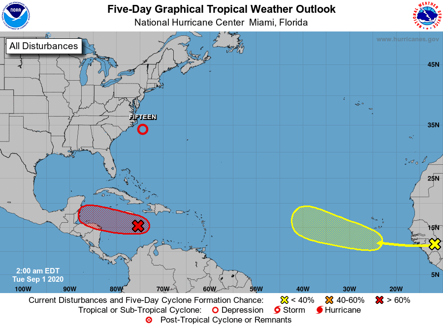
Tropical Weather Outlook
NWS National Hurricane Center Miami FL
200 AM EDT Tue Sep 1 2020
For the North Atlantic...Caribbean Sea and the Gulf of Mexico:
The National Hurricane Center is issuing advisories on Tropical
Depression Fifteen, located a little over a hundred miles south of
Cape Hatteras, North Carolina.
1. A seemingly well-organized cluster of showers and thunderstorms
associated with a tropical wave is moving quickly westward across
the central Caribbean Sea, but satellite-derived wind data from a
few hours ago again showed that the system has not developed a
closed surface wind circulation. The wave is, however, producing
an area of winds near tropical storm force south of the coast of
Haiti, which will move near or south of Jamaica later this morning.
Environmental conditions are expected to become a little more
conducive for development, and a tropical depression is likely to
form during the next couple of days before the system reaches
Central America Wednesday night. Locally heavy rains and gusty
winds are possible on Jamaica today, and interests there, as well as
in northern Nicaragua, Honduras, Belize, Guatemala, and the Yucatan
Peninsula, should monitor the progress of this disturbance.
* Formation chance through 48 hours...high...70 percent.
* Formation chance through 5 days...high...70 percent.
2. A tropical wave is expected to emerge off the coast of Africa in a
day or so. Gradual development of this system will be possible
through the end of the week while it moves slowly westward over the
far eastern tropical Atlantic Ocean.
* Formation chance through 48 hours...low...near 0 percent.
* Formation chance through 5 days...low...30 percent.
Public Advisories on Tropical Depression Fifteen are issued under
WMO header WTNT35 KNHC and under AWIPS header MIATCPAT5.
Forecast/Advisories on Tropical Depression Fifteen are issued under
WMO header WTNT25 KNHC and under AWIPS header MIATCMAT5.
Forecaster Berg