ZCZC MIATWOAT ALL
TTAA00 KNHC DDHHMM
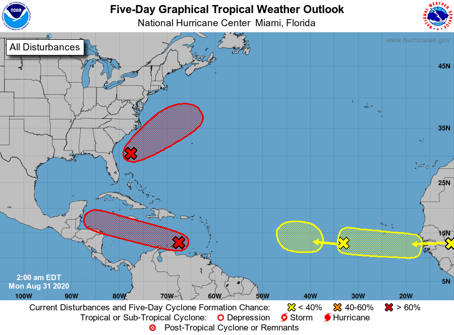
Tropical Weather Outlook
NWS National Hurricane Center Miami FL
200 AM EDT Mon Aug 31 2020
For the North Atlantic...Caribbean Sea and the Gulf of Mexico:
1. Recent satellite imagery and satellite-derived wind data indicate
that a broad area of low pressure associated with a tropical wave
over the eastern Caribbean Sea has changed little in organization
since yesterday. However, environmental conditions are expected to
gradually become more conducive for development, and a tropical
depression is likely to form during the next couple of days while
the system moves moves westward at at 15 to 20 mph. Interests in
Jamaica, Honduras, Belize, Guatemala and the Yucatan peninsula
should monitor the progress of this disturbance.
* Formation chance through 48 hours...high...70 percent.
* Formation chance through 5 days...high...80 percent.
2. An area of low pressure is located a few hundred miles east of
Jacksonville, Florida. This system has gradually gotten better
organized during the past 24 hours but is currently producing only
limited showers and thunderstorms. Additional development is
expected and a tropical depression is likely to form by the middle
of the week while the system moves northeastward or
east-northeastward, initially parallel to the southeastern coast of
the U.S. and then away from land. Upper-level winds are expected to
become less conducive for further development on Wednesday.
* Formation chance through 48 hours...medium...60 percent.
* Formation chance through 5 days...high...70 percent.
3. A tropical wave is expected to emerge off the coast of Africa in a
couple of days. Gradual development of this system will be possible
through the end of the week while it moves slowly westward over the
far eastern tropical Atlantic Ocean.
* Formation chance through 48 hours...low...near 0 percent.
* Formation chance through 5 days...low...30 percent.
4. Another tropical wave is located over the eastern Atlantic Ocean,
several hundred miles southwest of the Cabo Verde Islands. This
system is producing little shower activity, and any development of
this system should be slow to occur as it moves slowly westward.
* Formation chance through 48 hours...low...near 0 percent.
* Formation chance through 5 days...low...10 percent.
Forecaster Zelinsky