ZCZC MIATWOAT ALL
TTAA00 KNHC DDHHMM
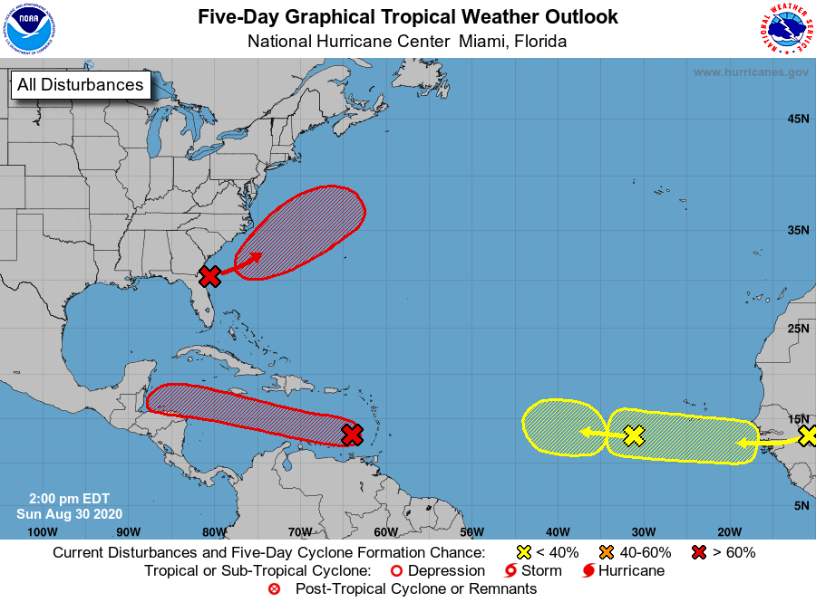
Tropical Weather Outlook
NWS National Hurricane Center Miami FL
200 PM EDT Sun Aug 30 2020
For the North Atlantic...Caribbean Sea and the Gulf of Mexico:
1. A westward-moving tropical wave accompanied by a broad low pressure
area is located over the eastern Caribbean Sea just west of the
Windward Islands. Associated shower and thunderstorm activity
continues to show signs of organization, and environmental
conditions are expected to gradually become more conducive for
development. A tropical depression is likely to form during the
next day or two while the system moves moves westward at about 15
mph across the central Caribbean Sea. Interests in Jamaica,
Honduras, Belize, Guatemala and Yucatan should monitor the progress
of this disturbance.
* Formation chance through 48 hours...high...70 percent.
* Formation chance through 5 days...high...80 percent.
2. An area of low pressure is expected to form off the southeastern
coast of the United States in a day or two. Subsequent development
of this system is possible, and a tropical depression is likely to
form by the middle of the week while the system moves northeastward
or east-northeastward, initially parallel to the southeastern coast
of the U.S. and then away from land.
* Formation chance through 48 hours...medium...60 percent.
* Formation chance through 5 days...high...70 percent.
3. A new tropical wave is expected to emerge off the coast of Africa
in a couple of days. Gradual development of this system will be
possible through the end of the week while it moves slowly westward
over the far eastern tropical Atlantic Ocean.
* Formation chance through 48 hours...low...near 0 percent.
* Formation chance through 5 days...low...30 percent.
4. A westward-moving tropical wave is located over the eastern Atlantic
Ocean, several hundred miles southwest of the Cabo Verde Islands.
This system is producing limited shower activity, and further
development is becoming less likely due to unfavorable environmental
conditions.
* Formation chance through 48 hours...low...near 0 percent.
* Formation chance through 5 days...low...20 percent.
Forecaster Stewart