ZCZC MIATWOAT ALL
TTAA00 KNHC DDHHMM
Tropical Weather Outlook
NWS National Hurricane Center Miami FL
800 AM EDT Wed Aug 19 2020
For the North Atlantic...Caribbean Sea and the Gulf of Mexico:
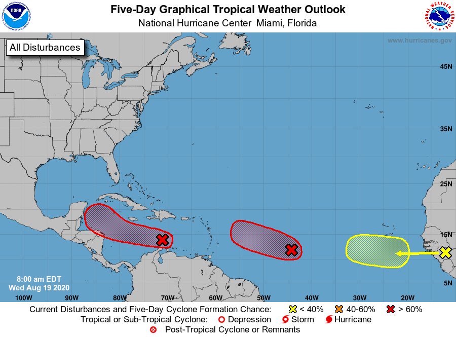
1. A tropical wave located over the eastern Caribbean Sea is producing
disorganized showers and thunderstorms, along with gusty winds in
these thunderstorms. Some gradual development of this system is
possible over next day or so while it moves westward at about 15 to
20 mph across the central Caribbean Sea. After that time, the wave
is forecast to move more slowly west-northwestward, and a tropical
depression is likely to form late this week or this weekend when the
system reaches the northwestern Caribbean Sea.
* Formation chance through 48 hours...medium...40 percent.
* Formation chance through 5 days...high...80 percent.
2. An elongated area of low pressure, located a little over 1000 miles
east of the Windward Islands continues to produce a concentrated
area of showers and thunderstorms mainly on the west side of the
disturbance. Environmental conditions are conducive for further
development, and a tropical depression is expected to form during
the next day or two while the system moves generally
west-northwestward at 15 to 20 mph across the central and western
portions of the tropical Atlantic.
* Formation chance through 48 hours...high...90 percent.
* Formation chance through 5 days...high...90 percent.
3. A large area of showers and thunderstorms, located over Guinea and
Sierra-Leone, Africa, is associated with a vigorous tropical wave.
Environmental conditions are expected to be marginally conducive for
some development of this system while the wave enters the extreme
eastern Atlantic on Friday. By early next week, however, conditions
are forecast to become less favorable for tropical cyclone formation
while it moves west-northwestward at 15 to 20 mph toward the central
tropical Atlantic.
* Formation chance through 48 hours...low...near 0 percent.
* Formation chance through 5 days...low...20 percent.
Forecaster Latto