ZCZC MIATWOAT ALL
TTAA00 KNHC DDHHMM
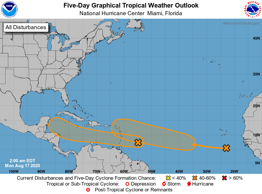
Tropical Weather Outlook
NWS National Hurricane Center Miami FL
200 AM EDT Mon Aug 17 2020
For the North Atlantic...Caribbean Sea and the Gulf of Mexico:
1. A fast-moving tropical wave located about 400 miles east of the
Windward Islands continues to produce disorganized shower and
thunderstorm activity. This disturbance is expected to move
westward at about 20 mph during the next few days, and that fast
forward speed is likely to limit significant development while the
system approaches the Windward and southern Leeward Islands today,
and moves across the eastern and central Caribbean Sea on Tuesday
and Wednesday. After that time, however, the system is expected to
move more slowly westward across the western Caribbean Sea, where
upper-level winds could become more conducive for the development
of a tropical depression during the latter part of this week.
Regardless of development, locally heavy rainfall and gusty winds
are expected over portions of the Windward and southern Leeward
Islands beginning this evening through Tuesday morning.
* Formation chance through 48 hours...low...20 percent.
* Formation chance through 5 days...medium...50 percent.
2. Another tropical wave located over the far eastern tropical Atlantic
well to the south-southeast of the Cabo Verde Islands is producing
a large area of cloudiness and disorganized showers. The wave is
forecast to move westward to west-northwestward at 15 to 20 mph
during the next few days, and environmental conditions are expected
to become more conducive for the development of a tropical
depression during the middle-to-latter part of this week while the
system moves across the central tropical Atlantic.
* Formation chance through 48 hours...low...10 percent.
* Formation chance through 5 days...medium...60 percent.
Forecaster Berg