ZCZC MIATWOAT ALL
TTAA00 KNHC DDHHMM
Tropical Weather Outlook
NWS National Hurricane Center Miami FL
200 AM EDT Tue Jul 21 2020
For the North Atlantic...Caribbean Sea and the Gulf of Mexico:
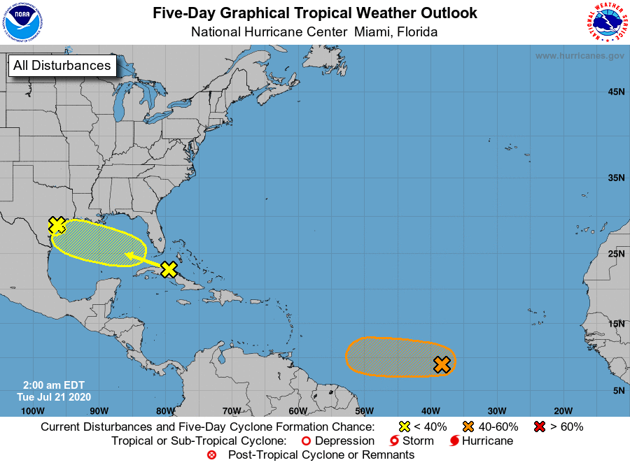
1. A tropical wave is producing a large area of disorganized showers
and thunderstorms over much of Cuba, the central and northwestern
Bahamas, southern Florida, and the adjacent Atlantic and Caribbean
waters. Gradual development of this system is possible while it
moves west-northwestward during the next few days. This system is
expected to move over the southeastern Gulf of Mexico by late
today, the central Gulf on Wednesday, and the northwestern Gulf on
Thursday and Friday. An Air Force Reserve Hurricane Hunter aircraft
is scheduled to investigate the system this afternoon, if
necessary.
* Formation chance through 48 hours...low...30 percent.
* Formation chance through 5 days...low...30 percent.
2. Showers and thunderstorms have increased and become a little better
organized in association with a low pressure system located about
midway between the west coast of Africa and the Lesser Antilles.
Environmental conditions are expected to be somewhat conducive for
development, and a tropical depression could form during the next
couple of days while the low moves westward at around 10 mph over
the tropical Atlantic. By the weekend, however, less favorable
conditions should limit additional development.
* Formation chance through 48 hours...medium...40 percent.
* Formation chance through 5 days...medium...40 percent.
3. A weak trough of low pressure has moved inland along the central and
upper Texas coasts. Although further weakening of this system is
expected, isolated heavy rainfall could still occur over portions of
southeastern Texas and southern Louisiana during the next day or
two. These rains could result in localized flash flooding.
* Formation chance through 48 hours...low...near 0 percent.
* Formation chance through 5 days...low...near 0 percent.
Forecaster Stewart