ZCZC MIATWOAT ALL
TTAA00 KNHC DDHHMM
Tropical Weather Outlook
NWS National Hurricane Center Miami FL
800 PM EDT Mon Oct 14 2019
For the North Atlantic...Caribbean Sea and the Gulf of Mexico:
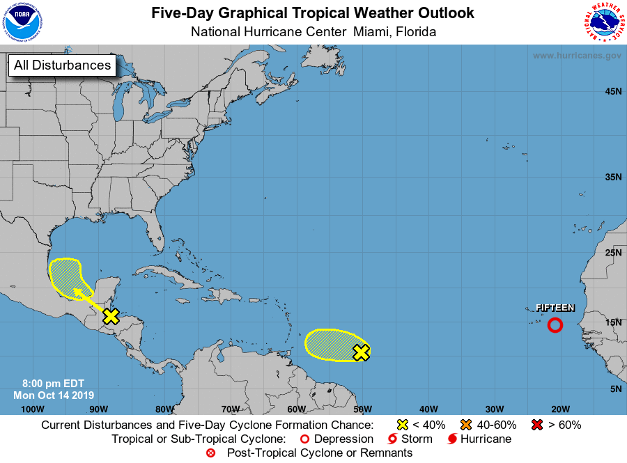
The National Hurricane Center is issuing advisories on newly formed
Tropical Depression Fifteen, located a few hundred miles southeast
of the Cabo Verde Islands.
1. Disorganized showers and thunderstorms over the southwestern
Caribbean Sea, Gulf of Honduras, and parts of Central America are
associated with a broad area of low pressure located inland over
northwestern Honduras. This system will move west-northwestward
across southern Belize, northern Guatemala, and southeastern Mexico
during the next day or so, preventing tropical cyclone formation
during that time. By Wednesday, however, the system is forecast to
emerge over the southern Bay of Campeche where conditions could
become a little more conducive for some organization to occur
later this week. Regardless of development, this system is
expected to produce heavy rains over a large portion of Central
America during the next couple of days, which could cause
flooding and mudslides, especially in mountainous areas.
* Formation chance through 48 hours...low...near 0 percent.
* Formation chance through 5 days...low...20 percent.
2. A tropical wave accompanied by a small low pressure system is
located about 750 miles east of the southern Windward Islands.
Although this system continues to produce a large area of
disorganized cloudiness and thunderstorms, upper-level winds are
only marginally conducive for additional development during the
next day or so while it moves westward at around 15 mph. On
Wednesday, upper-level winds are forecast to become quite hostile
when the wave approaches the Windward Islands and further
development is not anticipated after that time.
* Formation chance through 48 hours...low...20 percent.
* Formation chance through 5 days...low...20 percent.
Public Advisories on Tropical Depression Fifteen are issued under
WMO header WTNT35 KNHC and under AWIPS header MIATCPAT5.
Forecast/Advisories on Tropical Depression Fifteen are issued under
WMO header WTNT25 KNHC and under AWIPS header MIATCMAT5.
Forecaster Brown