ZCZC MIATWOAT ALL
TTAA00 KNHC DDHHMM
Tropical Weather Outlook
NWS National Hurricane Center Miami FL
200 PM EDT Mon Oct 14 2019
For the North Atlantic...Caribbean Sea and the Gulf of Mexico:
The National Hurricane Center has issued the last advisory on
Post-Tropical Cyclone Storm Melissa, located several hundred miles
south-southeast of Newfoundland, Canada.
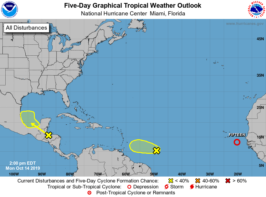
1. A large low pressure system located over the far eastern tropical
Atlantic Ocean less than 300 miles southeast of the Cabo Verde
Islands is moving slowly west-northwestward to northwestward.
Satellite imagery and surface wind data indicate that low has become
better defined since yesterday, and shower and thunderstorm activity
is showing increasing signs of organization. If this recent
development trend continues, then a tropical depression or a
tropical storm storm is likely to form later tonight or early
Tuesday while the low moves generally northwestward toward the Cabo
Verde Islands. Strong upper-level winds should prevent any further
development by midweek. This system is forecast to bring locally
heavy rainfall and gusty winds to portions of the Cabo Verde Islands
tonight through Wednesday morning, and interests there should
monitor the progress of this system.
* Formation chance through 48 hours...high...90 percent.
* Formation chance through 5 days...high...90 percent.
2. Disorganized showers and thunderstorms over the southwestern
Caribbean Sea, Gulf of Honduras, and parts of Central America are
associated with a broad area of low pressure located inland over
northwestern Honduras. This system will move west-northwestward
across southern Belize, northern Guatemala, and southeastern Mexico
during the next couple of days, preventing tropical cyclone
formation during that time. By Wednesday, however, the low is
forecast to emerge over the southern Bay of Campeche where
conditions could become a little more conducive for some further
organization to occur. Regardless of development, this system is
expected to produce heavy rains over a large portion of Central
America during the next few days, which could cause flooding and
mudslides, especially in mountainous areas.
* Formation chance through 48 hours...low...near 0 percent.
* Formation chance through 5 days...low...20 percent.
3. A tropical wave accompanied by a small low pressure system located
over the central tropical Atlantic is producing a large area of
cloudiness and thunderstorms. Although thunderstorm activity has
continued to increase and become a little better organized since
yesterday, upper-level winds are expected to be only marginally
conducive for significant development of this system over the next
day or two while it moves westward at around 15 mph. By late
Wednesday as the wave approaches the Windward Islands, upper-level
winds are forecast to become quite hostile for any further
development.
* Formation chance through 48 hours...low...20 percent.
* Formation chance through 5 days...low...20 percent.
Forecaster Stewart