ZCZC MIATWOAT ALL
TTAA00 KNHC DDHHMM
Special Tropical Weather Outlook
NWS National Hurricane Center Miami FL
830 AM EDT Fri Oct 11 2019
For the North Atlantic...Caribbean Sea and the Gulf of Mexico:
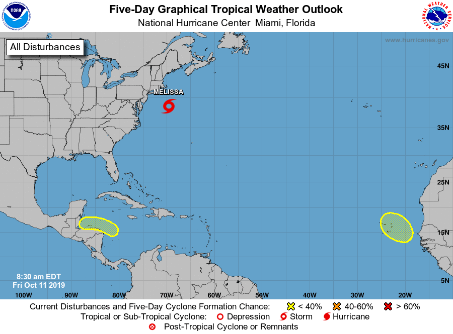
Special outlook issued to update discussion for the system southeast
of New England.
1. UPDATED: Early morning visible satellite imagery indicates that
shower and thunderstorm activity has continued to become better
organized near the center of a low pressure system located about 200
miles south-southeast of Martha's Vineyard. If this trend continues,
advisories will likely be issued for this system as a subtropical
storm later this morning. Upper-level winds are expected to increase
over the system during the weekend while the low weakens and moves
away from the northeastern United States. This low is already
producing storm-force winds, and is expected to continue meandering
off the coast through tonight, producing strong winds, coastal
flooding, heavy rainfall, and rough surf along portions of the
mid-Atlantic and northeastern United States coasts. Additional
information on this system can be found in local products and High
Seas Forecasts issued by the National Weather Service.
* Formation chance through 48 hours...medium...60 percent.
* Formation chance through 5 days...medium...60 percent.
2. A broad area of low pressure is expected to form over the western
Caribbean Sea during the weekend. This system is forecast to move
westward toward Central America early next week, and some
development is possible if the low remains over water while moving
near the coasts of Honduras, Guatemala, and Belize.
* Formation chance through 48 hours...low...near 0 percent.
* Formation chance through 5 days...low...20 percent.
3. A tropical wave, accompanied by a broad area of low pressure, is
expected to move off the west coast of Africa on Sunday. Although
the far eastern Atlantic is not climatologically favorable for
tropical cyclone formation this late in the hurricane season, some
development of this system appears possible early next week while
it moves generally northwestward near or over the Cabo Verde
Islands.
* Formation chance through 48 hours...low...near 0 percent.
* Formation chance through 5 days...low...20 percent.
High Seas Forecasts issued by the National Weather Service can be
found under AWIPS header NFDHSFAT1, WMO header FZNT01 KWBC, and
online at ocean.weather.gov/shtml/NFDHSFAT1.php
Forecaster Latto