ZCZC MIATWOAT ALL
TTAA00 KNHC DDHHMM
Tropical Weather Outlook
NWS National Hurricane Center Miami FL
200 AM EDT Sun Sep 22 2019
For the North Atlantic...Caribbean Sea and the Gulf of Mexico:
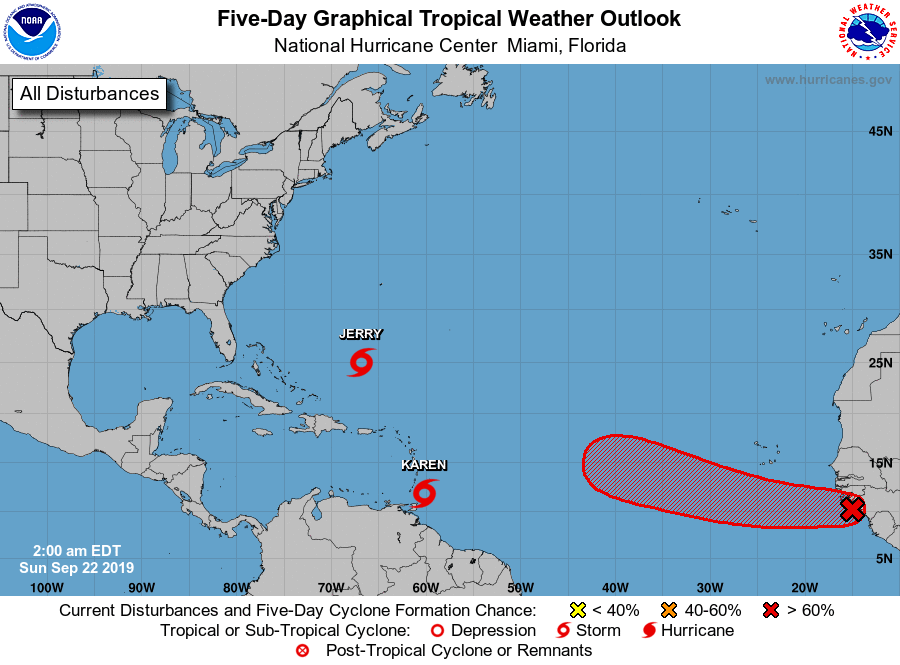
The National Hurricane Center is issuing advisories on Tropical
Storm Jerry, located several hundred miles south of Bermuda.
1. Satellite, radar and surface data indicate that the area of low
pressure located just north of Tobago in the Windward Islands is
becoming better organized and is producing winds to near tropical
storm force in the eastern portion of the system. Further
development of this disturbance is expected over the next couple of
days, and a tropical depression or tropical storm will likely form
while it moves west-northwestward and then northwestward at 10 to 15
mph across the Windward Islands and over the eastern Caribbean Sea.
The system is then expected to turn northward, moving near Puerto
Rico and the Virgin Islands on Tuesday. Heavy rainfall and strong
gusty winds are likely over much of the Leeward and Windward Islands
during the next couple of days and will spread across Puerto Rico
and the Virgin Islands by Monday night or Tuesday. Interests across
the eastern Caribbean should monitor the progress of this low, and
tropical storm watches and warnings will likely be required for
portions of the Leeward Islands and Puerto Rico later today. An Air
Force Hurricane Hunter is scheduled to investigate the system this
afternoon.
* Formation chance through 48 hours...high...80 percent.
* Formation chance through 5 days...high...80 percent.
2. A strong tropical wave along the west coast of Africa is already
producing thunderstorm activity that is showing some signs of
organization. Environmental conditions are conducive for further
development, and a tropical depression or tropical storm is expected
to form on Monday or Tuesday while it moves westward to west-
northwestward across the eastern tropical Atlantic at 15 to 20 mph.
* Formation chance through 48 hours...high...70 percent.
* Formation chance through 5 days...high...90 percent.
Further information on the system near the Windward Islands can be
found in High Seas Forecasts issued by the National Weather Service
can be found under AWIPS header NFDHSFAT1, WMO header FZNT01
KWBC, and online at ocean.weather.gov/shtml/NFDHSFAT1.php
Forecaster Blake