ZCZC MIATWOAT ALL
TTAA00 KNHC DDHHMM
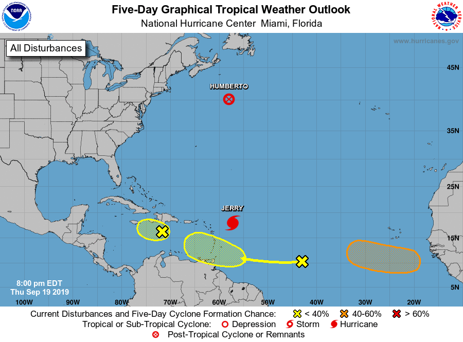
Tropical Weather Outlook
NWS National Hurricane Center Miami FL
800 PM EDT Thu Sep 19 2019
For the North Atlantic...Caribbean Sea and the Gulf of Mexico:
The National Hurricane Center is issuing advisories on Hurricane
Humberto, located several hundred miles northeast of Bermuda, and on
Hurricane Jerry, located a few hundred miles east of the Leeward
Islands.
1. A tropical wave located over the central tropical Atlantic is
producing a large area of disorganized cloudiness and showers. The
wave is expected to move quickly westward at about 20 mph during
the next few days, and some development is possible while it
approaches and moves across the Windward Islands this weekend.
Upper-level winds appear less conducive for development once the
wave moves over the eastern Caribbean Sea early next week.
* Formation chance through 48 hours...low...10 percent.
* Formation chance through 5 days...low...30 percent.
2. A broad area of low pressure located over the central Caribbean Sea
just south of Hispaniola is producing disorganized showers and
thunderstorms to the east and northeast of its center of
circulation. Upper-level winds are not conducive for significant
development of this system while it moves slowly west-northwestward
at about 5 mph. Regardless of development, locally heavy rainfall
is possible over portions of the Greater Antilles during the next
few days.
* Formation chance through 48 hours...low...10 percent.
* Formation chance through 5 days...low...10 percent.
3. A tropical wave is forecast to move off the west coast of Africa
this weekend. Environmental conditions are expected to be
conducive for development, and a tropical depression could form
early next week while the wave moves westward over the eastern
tropical Atlantic.
* Formation chance through 48 hours...low...near 0 percent.
* Formation chance through 5 days...medium...50 percent.
Forecaster Berg