ZCZC MIATWOAT ALL
TTAA00 KNHC DDHHMM
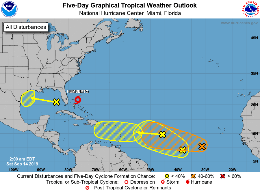
Tropical Weather Outlook
NWS National Hurricane Center Miami FL
200 AM EDT Sat Sep 14 2019
For the North Atlantic...Caribbean Sea and the Gulf of Mexico:
The National Hurricane Center is issuing advisories on recently
upgraded Tropical Storm Humberto, located near the northwestern
Bahamas.
1. A fast-moving tropical wave is located about 1000 miles east of the
Lesser Antilles. This system is producing limited shower activity,
and development, if any, should be slow to occur during the next
couple of days while the wave moves quickly westward across the
tropical Atlantic. Conditions could be a little more conducive for
development in a few days when the wave moves over the eastern
Caribbean Sea.
* Formation chance through 48 hours...low...10 percent.
* Formation chance through 5 days...low...20 percent.
2. Another tropical wave is located about 600 miles southwest of the
Cabo Verde Islands. Gradual development of this system is possible
during the next several days, and a tropical depression
could form early next week while it moves westward across the
tropical Atlantic.
* Formation chance through 48 hours...low...20 percent.
* Formation chance through 5 days...medium...60 percent.
3. An area of disturbed weather is located between the two tropical
waves mentioned above, about 1000 miles west-southwest of the Cabo
Verde Islands. This disturbance may merge with the tropical wave
approaching from the east over the weekend. However, some
development of this system is possible through early next week as
long as it remains a distinct system. The disturbance is forecast
to move slowly westward.
* Formation chance through 48 hours...low...10 percent.
* Formation chance through 5 days...low...20 percent.
4. A large area of showers and thunderstorms over the eastern Gulf of
Mexico is primarily associated with a upper-level low pressure
area. Only slow development of this system is likely during the
next couple of days. However, conditions could become more
conducive for development early next week as the system moves over
the western Gulf of Mexico.
* Formation chance through 48 hours...low...near 0 percent.
* Formation chance through 5 days...low...20 percent.
Forecaster Beven