ZCZC MIATWOAT ALL
TTAA00 KNHC DDHHMM CCA
Tropical Weather Outlook
NWS National Hurricane Center Miami FL
Issued by the NWS Weather Prediction Center College Park MD
200 PM EDT Wed Sep 11 2019
For the North Atlantic...Caribbean Sea and the Gulf of Mexico:
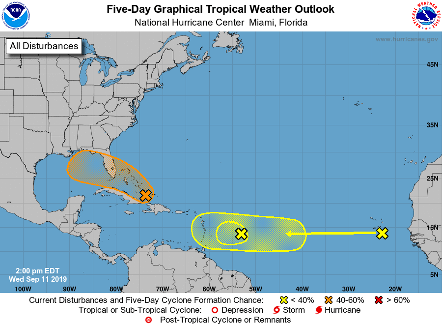
1. A large area of showers and thunderstorms was located along a
sharp surface trough from near eastern Cuba through the southeastern
Bahamas into the southwestern Atlantic. Conditions are forecast to
become more favorable for development late this week, and a tropical
depression could form near the northwestern Bahamas or South Florida
as early as Friday. Further development is possible over the eastern
Gulf of Mexico later this weekend. The disturbance will likely
produce periods of locally heavy rainfall and gusty winds across the
Bahamas through Friday, and across Florida during the weekend.
* Formation chance through 48 hours...medium...40 percent.
* Formation chance through 5 days...medium...60 percent.
2. A broad low pressure system, associated with a tropical wave, was
located about 500 miles east of the Lesser Antilles. This
disturbance is accompanied by a few thunderstorms showing little
organization. The system is forecast to move westward where
upper-level winds will become even less favorable for tropical
cyclone formation.
* Formation chance through 48 hours...low...10 percent.
* Formation chance through 5 days...low...10 percent.
3. A tropical wave located in the far eastern Atlantic Ocean near
the Cabo Verde Islands is forecast to move quickly westward
during the next several days. Environmental conditions may become
more favorable for development as the system approaches the Lesser
Antilles from late this weekend into early next week.
* Formation chance through 48 hours...low...near 0 percent.
* Formation chance through 5 days...low...30 percent.
Forecaster Burke/Blake