ZCZC MIATWOAT ALL
TTAA00 KNHC DDHHMM CCA
Tropical Weather Outlook...Corrected
NWS National Hurricane Center Miami FL
800 AM EDT Wed Sep 11 2019
Delete word and correct number
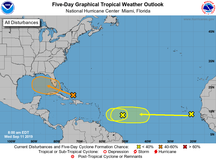
For the North Atlantic...Caribbean Sea and the Gulf of Mexico:
1. Widespread cloudiness and showers extending from the southeastern
Bahamas northward over the southwestern Atlantic for a few
hundred miles are associated with a surface trough of low pressure.
Limited development of this system is anticipated today or
tomorrow, however conditions are forecast to become a little more
favorable for development over the weekend, and a tropical
depression could form as the disturbance moves slowly toward the
west-northwest across the Florida Straits or South Florida and over
the eastern Gulf of Mexico. Regardless of development, this
disturbance could produce periods of locally heavy rainfall and
gusty winds across the Bahamas through Thursday, and across Florida
during the weekend.
* Formation chance through 48 hours...low...20 percent.
* Formation chance through 5 days...medium...60 percent.
2. A broad low pressure system, associated with a tropical wave, is
located about 650 miles east of the Lesser Antilles. This
disturbance is accompanied by a large but disorganized area of
cloudiness and thunderstorms. This system is forecast to move
westward toward unfavorable upper-level winds for tropical cyclone
formation.
* Formation chance through 48 hours...low...10 percent.
* Formation chance through 5 days...low...10 percent.
3. A tropical wave located between the west coast of Africa and the
Cabo Verde Islands is forecast to move quickly westward during the
next several days. Some slow development is possible over the
weekend or early next week when the system is moving over the
tropical Atlantic.
* Formation chance through 48 hours...low...near 0 percent.
* Formation chance through 5 days...low...20 percent.
Forecaster Avila